IMAGES TAKEN NEAR TO
Gorsty, Pembridge, LEOMINSTER, HR6 9JF
Introduction
This page details the photographs taken nearby to HR6 9JF by members of the Geograph project.
The Geograph project started in 2005 with the aim of publishing, organising and preserving representative images for every square kilometre of Great Britain, Ireland and the Isle of Man.

There are currently over 7.5m images from over14,400 individuals and you can help contribute to the project by visiting https://www.geograph.org.uk
Image Map
Images are licensed for reuse under creativecommons.org/licenses/by-sa/2.0
Notes
- Clicking on the map will re-center to the selected point.
- The higher the marker number, the further away the image location is from the centre of the postcode.
Image Listing (6 Images Found)
Images are licensed for reuse under creativecommons.org/licenses/by-sa/2.0
Image
Details
Distance
1
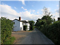
A house down a lane
This description could fit a lot of the settlement round here. Isolated homes and farms rather than definite villages.
Image: © Des Blenkinsopp
Taken: 23 Jun 2014
0.08 miles
2
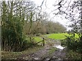
Carpenter's Wood
Edge of a small wood.
Image: © Richard Webb
Taken: 15 Feb 2014
0.14 miles
3
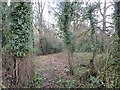
Carpenter's Wood
A small broadleaved woodland.
Image: © Richard Webb
Taken: 15 Feb 2014
0.14 miles
4

Decommissioned gate
I don't think there is any intention to continue using the gate.
Image: © Richard Webb
Taken: 15 Feb 2014
0.19 miles
5
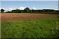
Ploughed field to the east of Weston
Image: © Philip Halling
Taken: 20 May 2007
0.20 miles
6
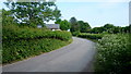
Gorsty to Weston lane
Weston Cottage can be seen to the left.
Image: © Jonathan Billinger
Taken: 9 Jun 2016
0.24 miles