IMAGES TAKEN NEAR TO
Staunton-on-Arrow, LEOMINSTER, HR6 9HT
Introduction
This page details the photographs taken nearby to HR6 9HT by members of the Geograph project.
The Geograph project started in 2005 with the aim of publishing, organising and preserving representative images for every square kilometre of Great Britain, Ireland and the Isle of Man.

There are currently over 7.5m images from over14,400 individuals and you can help contribute to the project by visiting https://www.geograph.org.uk
Image Map
Images are licensed for reuse under creativecommons.org/licenses/by-sa/2.0
Notes
- Clicking on the map will re-center to the selected point.
- The higher the marker number, the further away the image location is from the centre of the postcode.
Image Listing (5 Images Found)
Images are licensed for reuse under creativecommons.org/licenses/by-sa/2.0
Image
Details
Distance
1
The lane to Byton Hand near Stocklow Manor
Image: © Peter Whatley
Taken: 27 Sep 2011
0.13 miles
3
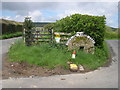
Entrance to Stocklow Manor Farm
An old millstone and a traffic cone mark the entrance to this farm. Wild flowers grow from the top of the plastic cone.
Image: © Philip Pankhurst
Taken: 30 Apr 2008
0.15 miles