IMAGES TAKEN NEAR TO
Pembridge, LEOMINSTER, HR6 9HF
Introduction
This page details the photographs taken nearby to HR6 9HF by members of the Geograph project.
The Geograph project started in 2005 with the aim of publishing, organising and preserving representative images for every square kilometre of Great Britain, Ireland and the Isle of Man.

There are currently over 7.5m images from over14,400 individuals and you can help contribute to the project by visiting https://www.geograph.org.uk
Image Map
Images are licensed for reuse under creativecommons.org/licenses/by-sa/2.0
Notes
- Clicking on the map will re-center to the selected point.
- The higher the marker number, the further away the image location is from the centre of the postcode.
Image Listing (6 Images Found)
Images are licensed for reuse under creativecommons.org/licenses/by-sa/2.0
Image
Details
Distance
3
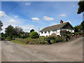
Lower Hardwick
Lower Hardwick is a handful of houses
Image: © Rob Hinkley
Taken: 14 May 2006
0.04 miles
4
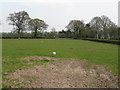
Lonely Lamb of Lower Hardwick
All on its own in a large field outside the village. What happened to its flock?
Image: © Peter Whatley
Taken: 19 Apr 2010
0.14 miles
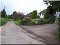
5
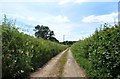
Three-wheeler unfriendly
A seldom used lane near Lower Hardwick.
Image: © Des Blenkinsopp
Taken: 25 Jun 2014
0.18 miles
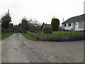
6
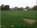
Houses outside Lower Hardwick
Looking northish from the bend in the road SE of Lower Hardwick
Image: © Rob Hinkley
Taken: 14 May 2006
0.23 miles