IMAGES TAKEN NEAR TO
Bearwood, LEOMINSTER, HR6 9EQ
Introduction
This page details the photographs taken nearby to HR6 9EQ by members of the Geograph project.
The Geograph project started in 2005 with the aim of publishing, organising and preserving representative images for every square kilometre of Great Britain, Ireland and the Isle of Man.

There are currently over 7.5m images from over14,400 individuals and you can help contribute to the project by visiting https://www.geograph.org.uk
Image Map
Images are licensed for reuse under creativecommons.org/licenses/by-sa/2.0
Notes
- Clicking on the map will re-center to the selected point.
- The higher the marker number, the further away the image location is from the centre of the postcode.
Image Listing (14 Images Found)
Images are licensed for reuse under creativecommons.org/licenses/by-sa/2.0
Image
Details
Distance
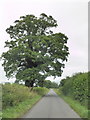
1
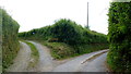
Diverging lanes near Bearwood
Left to The Cedars, right is the public road to Luntley.
Image: © Jonathan Billinger
Taken: 9 Jun 2016
0.04 miles

4
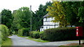
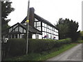
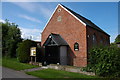
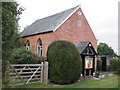
Bearwood black-and-white
A hamlet in the famed Black and White quarter of West Herefordshire.
Image: © Jonathan Billinger
Taken: 9 Jun 2016
0.12 miles
9

A Brand New Orchard
I'm guessing these are cider apples. After decades of losing out to lager, cider is back in fashion again and a lot of new orchards are being planted.
Image: © Des Blenkinsopp
Taken: 23 Jun 2014
0.19 miles
10

A Potato Field
Nice red soil around here.
Image: © Des Blenkinsopp
Taken: 23 Jun 2014
0.20 miles