IMAGES TAKEN NEAR TO
Bearwood, LEOMINSTER, HR6 9ED
Introduction
This page details the photographs taken nearby to HR6 9ED by members of the Geograph project.
The Geograph project started in 2005 with the aim of publishing, organising and preserving representative images for every square kilometre of Great Britain, Ireland and the Isle of Man.

There are currently over 7.5m images from over14,400 individuals and you can help contribute to the project by visiting https://www.geograph.org.uk
Image Map
Images are licensed for reuse under creativecommons.org/licenses/by-sa/2.0
Notes
- Clicking on the map will re-center to the selected point.
- The higher the marker number, the further away the image location is from the centre of the postcode.
Image Listing (13 Images Found)
Images are licensed for reuse under creativecommons.org/licenses/by-sa/2.0
Image
Details
Distance
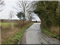
3
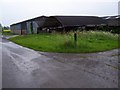
Barns and sheds
Farm buildings on the road from Lower Bearwood to Upper Hardwick.
Image: © Rob Hinkley
Taken: 13 May 2006
0.09 miles
4
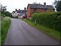
Lower Bearwood
Houses East of the crossroad, on the road from Lower Bearwood to Upper Hardwick.
Image: © Rob Hinkley
Taken: 13 May 2006
0.10 miles
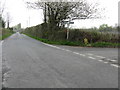
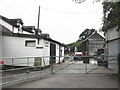
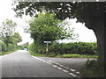
6
Bearwood Cross
A crossroads south of Pembridge.
Image: © Richard Webb
Taken: 15 Feb 2014
0.12 miles