IMAGES TAKEN NEAR TO
Eastmead, LEOMINSTER, HR6 0RD
Introduction
This page details the photographs taken nearby to Eastmead, HR6 0RD by members of the Geograph project.
The Geograph project started in 2005 with the aim of publishing, organising and preserving representative images for every square kilometre of Great Britain, Ireland and the Isle of Man.

There are currently over 7.5m images from over14,400 individuals and you can help contribute to the project by visiting https://www.geograph.org.uk
Image Map
Images are licensed for reuse under creativecommons.org/licenses/by-sa/2.0
Notes
- Clicking on the map will re-center to the selected point.
- The higher the marker number, the further away the image location is from the centre of the postcode.
Image Listing (5 Images Found)
Images are licensed for reuse under creativecommons.org/licenses/by-sa/2.0
Image
Details
Distance
1
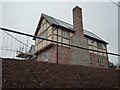
New Housing Development (Stoke Prior)
New housing development is currently being built by Border Oak on the outskirts of Stoke Prior in Herefordshire. Looks fab so far!
Image: © Fabian Musto
Taken: 27 Oct 2018
0.01 miles
2
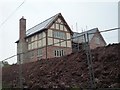
New Housing Development (Stoke Prior)
New housing development is currently being built by Border Oak on the outskirts of Stoke Prior in Herefordshire. Looks fab so far!
Image: © Fabian Musto
Taken: 27 Oct 2018
0.01 miles
3
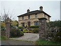
Victorian House (Stoke Prior)
Posh Victorian house on the outskirts of Stoke Prior in Herefordshire.
Image: © Fabian Musto
Taken: 27 Oct 2018
0.06 miles
4
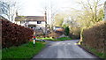
Cottage and lane
The road descends gently to Stoke Prior
Image: © Jonathan Billinger
Taken: 24 Dec 2014
0.10 miles
5
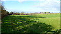
Pasture land east of Stoke Prior
Land is gently descending to the Lugg valley floor.
In the far distance are the South Shropshire hills.
Image: © Jonathan Billinger
Taken: 24 Dec 2014
0.23 miles