IMAGES TAKEN NEAR TO
Hope-under-Dinmore, LEOMINSTER, HR6 0PL
Introduction
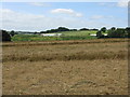
This page details the photographs taken nearby to HR6 0PL by members of the Geograph project.
The Geograph project started in 2005 with the aim of publishing, organising and preserving representative images for every square kilometre of Great Britain, Ireland and the Isle of Man.

There are currently over 7.5m images from over14,400 individuals and you can help contribute to the project by visiting https://www.geograph.org.uk
Image Map
Images are licensed for reuse under creativecommons.org/licenses/by-sa/2.0
Notes
- Clicking on the map will re-center to the selected point.
- The higher the marker number, the further away the image location is from the centre of the postcode.
Image Listing (2 Images Found)
Images are licensed for reuse under creativecommons.org/licenses/by-sa/2.0
Image
Details
Distance
1
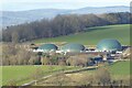
Anaerobic digestion plant
Anaerobic digestion plant at Bowley Court above the Lugg valley, viewed here from a bridleway on Dinmore Hill.
Image: © Philip Halling
Taken: 27 Jan 2022
0.10 miles