IMAGES TAKEN NEAR TO
Sunset Yard, KINGTON, HR5 3SG
Introduction
This page details the photographs taken nearby to Sunset Yard, HR5 3SG by members of the Geograph project.
The Geograph project started in 2005 with the aim of publishing, organising and preserving representative images for every square kilometre of Great Britain, Ireland and the Isle of Man.

There are currently over 7.5m images from over14,400 individuals and you can help contribute to the project by visiting https://www.geograph.org.uk
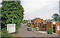
Image Map
Images are licensed for reuse under creativecommons.org/licenses/by-sa/2.0
Notes
- Clicking on the map will re-center to the selected point.
- The higher the marker number, the further away the image location is from the centre of the postcode.
Image Listing (61 Images Found)
Images are licensed for reuse under creativecommons.org/licenses/by-sa/2.0
Image
Details
Distance
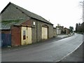
1
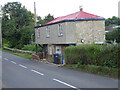
Toll House, Kington
"Sunset Cottage" on the B4355 NE of Kington. Erected by the Kington Turnpike Trust in the 19ᵗʰ C. More local toll houses see https://www.geograph.org.uk/discuss/index.php?&action=vthread&forum=11&topic=33104
Milestone Society National ID: HF.KIN05
Image: © Mr Red
Taken: 9 Sep 2022
0.02 miles
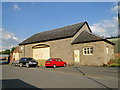
2
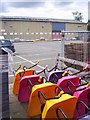
Bright Barrows
In a garden centre or builders merchant yard on the edge of Kington.
Image: © Des Blenkinsopp
Taken: 22 Jun 2014
0.03 miles
3
Goods shed by the station 2
In my efforts to track the New Radnor line and where it went I come to Kington where this good shed remains, the station would have been opposite and the railway would have led off in the left of the photo.
Image: © Bill Nicholls
Taken: 2 May 2010
0.04 miles
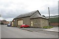
4

Kington goods shed
The former Great Western Railway goods shed at Kington. This and the original 1857 station building - see Image - are the most prominent remains of the town's railway history.
Image: © John Winder
Taken: 12 Apr 2009
0.04 miles
5
Goods shed by the station
In my efforts to track the New Radnor line and where it went I come to Kington where this good shed remains, the station would have been opposite.
Image: © Bill Nicholls
Taken: 2 May 2010
0.04 miles
6
Former goods shed
Now being used for storage. The area which was previously the railway line now has industrial units built on. The "new" station would have been just to the right of this photograph.
Behind the former goods shed is Kington Ambulance Station.
Image: © David Luther Thomas
Taken: 13 Jan 2007
0.04 miles
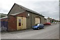
7
Goods Shed, Kington
A good number of buildings remain to remind us of the Kington railways. This is the best goods shed and it is virtually unaltered since it saw its last train in 1964.
Image: © Philip Pankhurst
Taken: 26 Jun 2010
0.05 miles
8
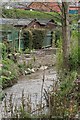
Remains of the bridge
Here you can just make out the remains of the bridge that spanned the Langdale brook (now Back Brook) before going into Kington station.
Image: © Bill Nicholls
Taken: 2 May 2010
0.05 miles
9
Kington: eastward near site of former station
The station had been along on the right; the furthest building is the surviving goods shed. On the ex-GWR Leominster - New Radnor line, the station was closed to passengers 7/2/55 (goods 28/9/64), when the line here from Leominster was closed. Closure on to New Radnor had been earlier: 4/2/51 for passengers and 31/12/51 for goods.
Image: © Ben Brooksbank
Taken: 3 Sep 1999
0.05 miles
10
Remains of the bridge
This is all that remains of the once railway bridge that took the line into Kington station
Image: © Bill Nicholls
Taken: 2 May 2010
0.05 miles