IMAGES TAKEN NEAR TO
Colva, KINGTON, HR5 3RA
Introduction
This page details the photographs taken nearby to HR5 3RA by members of the Geograph project.
The Geograph project started in 2005 with the aim of publishing, organising and preserving representative images for every square kilometre of Great Britain, Ireland and the Isle of Man.

There are currently over 7.5m images from over14,400 individuals and you can help contribute to the project by visiting https://www.geograph.org.uk
Image Map (Loading...)


Getting Data...Please wait
Leaflet Map data © OpenStreetMap
Images are licensed for reuse under creativecommons.org/licenses/by-sa/2.0
Notes
- Clicking on the map will re-center to the selected point.
- The higher the marker number, the further away the image location is from the centre of the postcode.
Image Listing (4 Images Found)
Images are licensed for reuse under creativecommons.org/licenses/by-sa/2.0
Image
Details
Distance
1
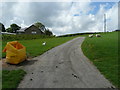
Farm road at Llanhaylow
A newly-built bungalow has fine views towards Hergest Ridge.
Image: © Jonathan Billinger
Taken: 20 May 2008
0.03 miles
2
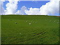
Sheep on the hillside
Fine grass country near Llanhaylow.
Image: © Jonathan Billinger
Taken: 20 May 2008
0.09 miles
3
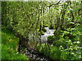
Upper Gladestry Brook
Flowing east past the farm road between Llanhaylow and Cwmynace.
Image: © Jonathan Billinger
Taken: 20 May 2008
0.17 miles
4
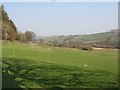
Farmland, Colva
Lower altitude farmland in the valley below Colva. Grazing for sheep and cattle.
Image: © Richard Webb
Taken: 1 Apr 2007
0.24 miles