IMAGES TAKEN NEAR TO
Mission Hut Mews, Moor Court Lane, KINGTON, HR5 3QY
Introduction
This page details the photographs taken nearby to Mission Hut Mews, Moor Court Lane, HR5 3QY by members of the Geograph project.
The Geograph project started in 2005 with the aim of publishing, organising and preserving representative images for every square kilometre of Great Britain, Ireland and the Isle of Man.

There are currently over 7.5m images from over14,400 individuals and you can help contribute to the project by visiting https://www.geograph.org.uk
Image Map
Images are licensed for reuse under creativecommons.org/licenses/by-sa/2.0
Notes
- Clicking on the map will re-center to the selected point.
- The higher the marker number, the further away the image location is from the centre of the postcode.
Image Listing (8 Images Found)
Images are licensed for reuse under creativecommons.org/licenses/by-sa/2.0
Image
Details
Distance
2
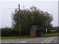
Iron building, Holme Marsh
Small building on the green at Holme Marsh.
Image: © Richard Webb
Taken: 15 Feb 2014
0.04 miles
3
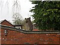
Chainsaw sculpture
Bear behind electric gates.
Image: © Richard Webb
Taken: 15 Feb 2014
0.06 miles
5
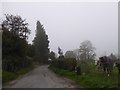
The road to Pennsylvania from Holme Marsh
Pennsylvania farm is a short distance down this road off the A480
Image: © David Smith
Taken: 19 Oct 2017
0.14 miles
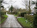
6
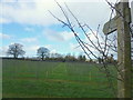
Footpath to Holme Marsh
The rows of the recently-planted orchard are not aligned to the direction of the footpath.
Image: © Jonathan Billinger
Taken: 10 Feb 2016
0.17 miles
7
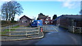
Upper Holme Farm
Home of an outside catering business.
Image: © Jonathan Billinger
Taken: 10 Feb 2016
0.17 miles
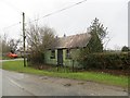
8
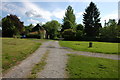
Small green at Holme Marsh
The track continues as a footpath to Summer Court.
Image: © Philip Halling
Taken: 20 May 2007
0.19 miles