IMAGES TAKEN NEAR TO
Colva, KINGTON, HR5 3QX
Introduction
This page details the photographs taken nearby to HR5 3QX by members of the Geograph project.
The Geograph project started in 2005 with the aim of publishing, organising and preserving representative images for every square kilometre of Great Britain, Ireland and the Isle of Man.

There are currently over 7.5m images from over14,400 individuals and you can help contribute to the project by visiting https://www.geograph.org.uk
Image Map
Images are licensed for reuse under creativecommons.org/licenses/by-sa/2.0
Notes
- Clicking on the map will re-center to the selected point.
- The higher the marker number, the further away the image location is from the centre of the postcode.
Image Listing (5 Images Found)
Images are licensed for reuse under creativecommons.org/licenses/by-sa/2.0
Image
Details
Distance
1
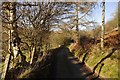
Ffynnonau road
Nearing the transition from tar to mud.
Image: © Richard Webb
Taken: 28 Dec 2016
0.09 miles
2
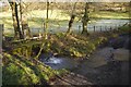
Ford, Middle Ffynnonau
This road can get pretty muddy, especially when drainage is impeded by dead leaves.
Image: © Richard Webb
Taken: 28 Dec 2016
0.10 miles
3
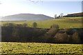
Radnor Forest farmland
At the foot of Cnwch Bank.
Image: © Richard Webb
Taken: 28 Dec 2016
0.13 miles
4
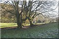
Boundary beeches, Middle Ffynnonau
Possible grown up hedgerow trees.
Image: © Richard Webb
Taken: 28 Dec 2016
0.24 miles
5
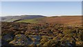
Colva Hill
Typical Radnor Forest moorland.
Image: © Richard Webb
Taken: 28 Dec 2016
0.24 miles