IMAGES TAKEN NEAR TO
Mahollem, KINGTON, HR5 3PT
Introduction
This page details the photographs taken nearby to HR5 3PT by members of the Geograph project.
The Geograph project started in 2005 with the aim of publishing, organising and preserving representative images for every square kilometre of Great Britain, Ireland and the Isle of Man.

There are currently over 7.5m images from over14,400 individuals and you can help contribute to the project by visiting https://www.geograph.org.uk
Image Map (Loading...)


Getting Data...Please wait
Leaflet Map data © OpenStreetMap
Images are licensed for reuse under creativecommons.org/licenses/by-sa/2.0
Notes
- Clicking on the map will re-center to the selected point.
- The higher the marker number, the further away the image location is from the centre of the postcode.
Image Listing (6 Images Found)
Images are licensed for reuse under creativecommons.org/licenses/by-sa/2.0
Image
Details
Distance
4
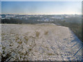
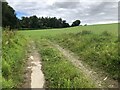
Overlooking the Arrow valley
From Upper Hergest Lane looking south-west across sheep pasture. Strange narrow field on the right, which leads all the way down to the valley bottom, perhaps once was an old lane.
Image: © Trevor Rickard
Taken: 4 Jan 2010
0.23 miles