IMAGES TAKEN NEAR TO
Gladestry, KINGTON, HR5 3PN
Introduction
This page details the photographs taken nearby to HR5 3PN by members of the Geograph project.
The Geograph project started in 2005 with the aim of publishing, organising and preserving representative images for every square kilometre of Great Britain, Ireland and the Isle of Man.

There are currently over 7.5m images from over14,400 individuals and you can help contribute to the project by visiting https://www.geograph.org.uk
Image Map
Images are licensed for reuse under creativecommons.org/licenses/by-sa/2.0
Notes
- Clicking on the map will re-center to the selected point.
- The higher the marker number, the further away the image location is from the centre of the postcode.
Image Listing (8 Images Found)
Images are licensed for reuse under creativecommons.org/licenses/by-sa/2.0
Image
Details
Distance
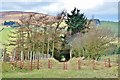
1
Gwernilla
Grassland on a spur. Currently grazed by sheep.
Image: © Richard Webb
Taken: 1 Apr 2007
0.16 miles
3
Lane, Gwenilla
A narrow road east of Colva.
Image: © Richard Webb
Taken: 28 Dec 2016
0.19 miles
4

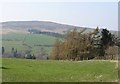
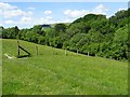
Valley east of Colva
Farmland in the valley between Colva and Gladestry.
Image: © Philip Halling
Taken: 22 Jun 2019
0.19 miles
6
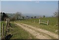
Track, Gwernilla
Lane connecting a pair of minor roads.
Image: © Richard Webb
Taken: 1 Apr 2007
0.21 miles
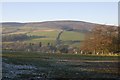
7
Valley near Colva
Valley between Colva and Gladestry.
Image: © Philip Halling
Taken: 22 Jun 2019
0.23 miles
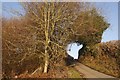
8
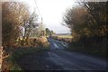
An icy road
Colfa to Hengoed road with day long fog over Herefordshire. I was later asked why had gone out on such a dismal day? Rather different conditions up on the hills during an inversion.
Image: © Richard Webb
Taken: 28 Dec 2016
0.23 miles