IMAGES TAKEN NEAR TO
Huntington, KINGTON, HR5 3PG
Introduction
This page details the photographs taken nearby to HR5 3PG by members of the Geograph project.
The Geograph project started in 2005 with the aim of publishing, organising and preserving representative images for every square kilometre of Great Britain, Ireland and the Isle of Man.

There are currently over 7.5m images from over14,400 individuals and you can help contribute to the project by visiting https://www.geograph.org.uk
Image Map
Images are licensed for reuse under creativecommons.org/licenses/by-sa/2.0
Notes
- Clicking on the map will re-center to the selected point.
- The higher the marker number, the further away the image location is from the centre of the postcode.
Image Listing (4 Images Found)
Images are licensed for reuse under creativecommons.org/licenses/by-sa/2.0
Image
Details
Distance
1
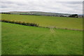
Farmland near Huntington
View across grazing land near Huntington. Hergest Ridge can be seen in the background.
Image: © Philip Halling
Taken: 5 May 2012
0.15 miles
2
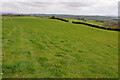
Grazing land near Huntington
At around 1000ft above sea level this grazing land above the Arrow valley near Huntington provides wonderful views over England with Clee Hill in Shropshire to the north-east, the Malvern Hills on the Worcestershire/Herefordshire border to the east, May Hill in Gloucestershire on the northern edge of the Forest of Dean and the Cotswolds beyond. On the day this picture was taken all these hills were visible to the naked eye, unfortunately they are not visible in this picture.
Image: © Philip Halling
Taken: 5 May 2012
0.18 miles
3
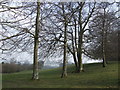
Group of beeches
This copse may be spared the ravages of climate change by virtue of their position at 1000' above sea level in the most westerly corner of Herefordshire.
Image: © Jonathan Billinger
Taken: 26 Mar 2007
0.18 miles
4
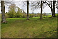
Trees and farmland
A footpath passes between these trees en route to Huntington church.
Image: © Philip Halling
Taken: 5 May 2012
0.18 miles