IMAGES TAKEN NEAR TO
Floodgates, KINGTON, HR5 3NQ
Introduction
This page details the photographs taken nearby to HR5 3NQ by members of the Geograph project.
The Geograph project started in 2005 with the aim of publishing, organising and preserving representative images for every square kilometre of Great Britain, Ireland and the Isle of Man.

There are currently over 7.5m images from over14,400 individuals and you can help contribute to the project by visiting https://www.geograph.org.uk
Image Map (Loading...)


Getting Data...Please wait
Leaflet Map data © OpenStreetMap
Images are licensed for reuse under creativecommons.org/licenses/by-sa/2.0
Notes
- Clicking on the map will re-center to the selected point.
- The higher the marker number, the further away the image location is from the centre of the postcode.
Image Listing (126 Images Found)
Images are licensed for reuse under creativecommons.org/licenses/by-sa/2.0
Image
Details
Distance
1
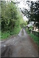
End of Prospect Road
I think this may well have been the end of Prospect Road before the new road cut it in two, the road would have gone through a ford at one time.
Image: © Bill Nicholls
Taken: 2 May 2010
0.01 miles
2

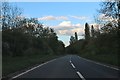
Minor road heads away from Kington
Beyond the northern end of Prospect Road, a minor road climbs away from the A44.
The Kington boundary sign http://www.geograph.org.uk/photo/3530867 is behind the camera.
Image: © Jaggery
Taken: 26 Jun 2013
0.02 miles
3
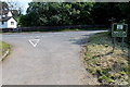
Lane meeting the A44, Kington
A field path from Barton and the Offa's Dyke path cross the A44 at this point. The road sign reads 'Kington - the Centre for Walking'.
Image: © Jim Barton
Taken: 4 Jul 2012
0.02 miles
5
Welcome to Kington, the centre for walking
A minor road reaches the A44 at the northern boundary of Kington, a small town in NW Herefordshire.
Image: © Jaggery
Taken: 26 Jun 2013
0.03 miles
6
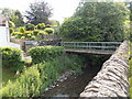
Back Brook footbridge, Kington
Viewed from the A44 side. Back Brook is a tributary of the River Arrow.
Image: © Jaggery
Taken: 26 Jun 2013
0.03 miles
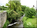
7
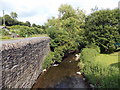
Back Brook, Kington
Viewed from this http://www.geograph.org.uk/photo/3530941 footbridge. Back Brook is a tributary of the River Arrow. The A44 is on the left.
Image: © Jaggery
Taken: 26 Jun 2013
0.03 miles
8
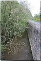
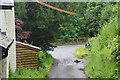
Wall by the brook
The wall here is there to stop the brook eroding away at the road to the right though I was told there used to be a ford nearby so it may well be a new addition.
Image: © Bill Nicholls
Taken: 2 May 2010
0.04 miles
9
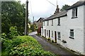
Cottages by Back Brook, Kington
Taken from the bridge over Back Brook, where the Offa's Dyke route enters the town from the north.
Image: © Jim Barton
Taken: 4 Jul 2012
0.05 miles
10
Back Brook
Tributary of the River Arrow, in Kington. This is where the Offa's Dyke National Trail crosses this watercourse next to the A44 bypass.
Image: © Chris Heaton
Taken: 16 May 2007
0.05 miles