IMAGES TAKEN NEAR TO
Gladestry, KINGTON, HR5 3ND
Introduction
This page details the photographs taken nearby to HR5 3ND by members of the Geograph project.
The Geograph project started in 2005 with the aim of publishing, organising and preserving representative images for every square kilometre of Great Britain, Ireland and the Isle of Man.

There are currently over 7.5m images from over14,400 individuals and you can help contribute to the project by visiting https://www.geograph.org.uk
Image Map
Images are licensed for reuse under creativecommons.org/licenses/by-sa/2.0
Notes
- Clicking on the map will re-center to the selected point.
- The higher the marker number, the further away the image location is from the centre of the postcode.
Image Listing (6 Images Found)
Images are licensed for reuse under creativecommons.org/licenses/by-sa/2.0
Image
Details
Distance
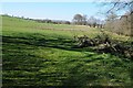
1
Stonehouse Barn
Newly planted trees in the grounds of this dwelling at 1000' elevation.
Image: © Jonathan Billinger
Taken: 26 Mar 2007
0.03 miles
2
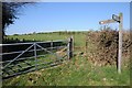
Offa's Dyke Path
A footpath signpost on Offa's Dyke Path to the west of Huntington.
Image: © Philip Halling
Taken: 18 Apr 2015
0.08 miles
3
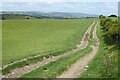
Field track above Gladestry
Field track above Gladestry viewed from Offa's Dyke Path.
Image: © Philip Halling
Taken: 12 Jun 2022
0.10 miles
4
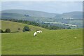
View to the Radnor Hills
Sheep gazing in a field with a view beyond of the Radnor Hills from Offa's Dyke Path above Galdestry.
Image: © Philip Halling
Taken: 12 Jun 2022
0.11 miles
5
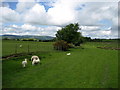
Field west of Llanbella
Offa's Dyke National Trail follows the field boundary in this photograph, roughly halfway between Newchurch and Gladestry.
Image: © Chris Heaton
Taken: 15 May 2007
0.22 miles