IMAGES TAKEN NEAR TO
Lyonshall, KINGTON, HR5 3LU
Introduction
This page details the photographs taken nearby to HR5 3LU by members of the Geograph project.
The Geograph project started in 2005 with the aim of publishing, organising and preserving representative images for every square kilometre of Great Britain, Ireland and the Isle of Man.

There are currently over 7.5m images from over14,400 individuals and you can help contribute to the project by visiting https://www.geograph.org.uk
Image Map
Images are licensed for reuse under creativecommons.org/licenses/by-sa/2.0
Notes
- Clicking on the map will re-center to the selected point.
- The higher the marker number, the further away the image location is from the centre of the postcode.
Image Listing (4 Images Found)
Images are licensed for reuse under creativecommons.org/licenses/by-sa/2.0
Image
Details
Distance
2
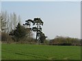
Drovers' sign post
Scots pines were used to mark drovers' routes and stances. While these trees are probably too young, they may have been planted to tradition replacing a previous tree. This crossroads, on the edge of Lyonshall is on the road to Worcester and would have been a busy route with cattle being driven from Wales to Worcester and beyond. The habit of planting pines on hill tops may also have had a navigation function, although in recent years many such clumps have been lost to the wind or forestry.
Image: © Richard Webb
Taken: 1 Apr 2007
0.12 miles
4
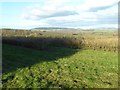
View to the Shobdon Hills
View to the Shobdon Hills from beside the A44. I'm not sure what crop is being grown in the field in the foreground, possibly currents.
Image: © Philip Halling
Taken: 2 Feb 2018
0.15 miles