IMAGES TAKEN NEAR TO
Spond, KINGTON, HR5 3LE
Introduction
This page details the photographs taken nearby to HR5 3LE by members of the Geograph project.
The Geograph project started in 2005 with the aim of publishing, organising and preserving representative images for every square kilometre of Great Britain, Ireland and the Isle of Man.

There are currently over 7.5m images from over14,400 individuals and you can help contribute to the project by visiting https://www.geograph.org.uk
Image Map (Loading...)


Getting Data...Please wait
Leaflet Map data © OpenStreetMap
Images are licensed for reuse under creativecommons.org/licenses/by-sa/2.0
Notes
- Clicking on the map will re-center to the selected point.
- The higher the marker number, the further away the image location is from the centre of the postcode.
Image Listing (36 Images Found)
Images are licensed for reuse under creativecommons.org/licenses/by-sa/2.0
Image
Details
Distance
1
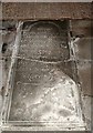
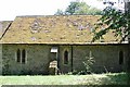
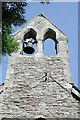
Bollingham Church
Bollingham church is dedicated to St Silas.
Image: © Philip Halling
Taken: 20 May 2007
0.01 miles
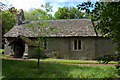
2
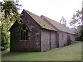
St Silas, Bollingham
Tiny church between Eardisley and Kington, set in the grounds of Bollingham House.
Image: © Philip Pankhurst
Taken: 29 Aug 2010
0.01 miles
3
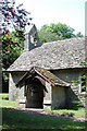
St Silas, Bollingham, Herefordshire - porch
Image: © John Salmon
Taken: 14 Jul 2003
0.01 miles
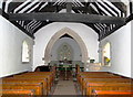
9
St Silas, Bollingham
Ropey shot of this tiny church between Eardisley and Kington, taken in poor light.
Image: © Philip Pankhurst
Taken: 29 Aug 2010
0.02 miles