IMAGES TAKEN NEAR TO
Lyonshall, KINGTON, HR5 3JZ
Introduction
This page details the photographs taken nearby to HR5 3JZ by members of the Geograph project.
The Geograph project started in 2005 with the aim of publishing, organising and preserving representative images for every square kilometre of Great Britain, Ireland and the Isle of Man.

There are currently over 7.5m images from over14,400 individuals and you can help contribute to the project by visiting https://www.geograph.org.uk
Image Map
Images are licensed for reuse under creativecommons.org/licenses/by-sa/2.0
Notes
- Clicking on the map will re-center to the selected point.
- The higher the marker number, the further away the image location is from the centre of the postcode.
Image Listing (28 Images Found)
Images are licensed for reuse under creativecommons.org/licenses/by-sa/2.0
Image
Details
Distance
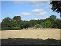
1
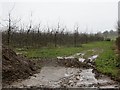
Orchard, Moorcot
There are more orchards around here than are currently mapped.
Image: © Richard Webb
Taken: 15 Feb 2014
0.07 miles
2
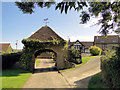
Gatehouse, Moor Court Farm
Venue for the annual Weobley and District ploughing match. Dating, in part, from the 15th century.
Image: © Philip Pankhurst
Taken: 12 Nov 2012
0.12 miles
3
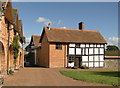
Moor Court Farm
In splendid condition, with a range of converted outbuildings.
Image: © Philip Pankhurst
Taken: 29 Sep 2012
0.13 miles
4
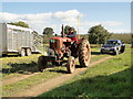
The annual Weobley and District Ploughing Match
Held this year at Moor Court Farm. A contestant leaves the field of play after competing.
Image: © Philip Pankhurst
Taken: 29 Sep 2012
0.16 miles
5
View from the churchyard, Moorcot
Looking across a hay field to one of the handful of houses that comprise the hamlet of Moorcot.
Image: © Des Blenkinsopp
Taken: 24 Jun 2014
0.18 miles
6
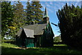
Moorcourt Church
This unusual church is dedicated to St Mary and is constructed in iron. It was built in the mid-1800’s on the estate of Moorcourt. During 2004/5 the church underwent extensive repair work.
Image: © Philip Halling
Taken: 20 May 2007
0.22 miles
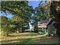
7
Moorcot Parish Hall
I am guessing this is the parish room as it's just across the churchyard from the equally diminutive Moorcot church. Image
Phillip Halling must have been there in the afternoon to take that shot, as when I was there the church was completely shadowed under large trees.
This place however was lit perfectly by the morning sun.
Updates :- Several comments about this. Thanks to all.
" I believe this building to be the Sunday School in its origin but used for many different things over the years." from Paul Wood.
"Hereford county council website http://htt.herefordshire.gov.uk/799.aspx says "Within the grounds of the chapel is a separate smaller timber-framed building of one room. It may have once been used for the Sunday School." so they don't seem certain." from Penny Mayes.
And from Paul again "I know it was me who did the research. The report I did for the council I suggested it was from records at the records office suggesting a build date and its intention of use but was not confirmed with any further correspondence for an actual build date or use other than local knowledge where people in the village confirmed it was where they went to Sunday School. But this does not mean it was not once the Parish Room as well."
Image: © Des Blenkinsopp
Taken: 24 Jun 2014
0.22 miles
8
Trees at St. Mary's church (Moorcourt)
The trees in the grassland at St. Mary's church are fantastic, a highlight of my visit to the area.
Image: © Fabian Musto
Taken: 10 Jun 2022
0.23 miles
9
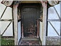
Doorway inside the former Sunday school (Moorcourt)
This wooden door provides access to the former Sunday school building at Moorcourt from the south. The door wasn't shut properly when I visited (oh dear).
Image: © Fabian Musto
Taken: 10 Jun 2022
0.23 miles
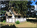
10
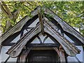
Former Sunday school (Porch | Moorcourt)
This timber-framed building was added on the grounds of St. Mary's church at the end of the 19th century, and this housed the Sunday school. The church is still in use as of 2022, but the Sunday school is now a storage room. The building has seen better days with some of the glass in the windows removed, but this was grade II listed on 25th August 2020.
Image: © Fabian Musto
Taken: 10 Jun 2022
0.23 miles