IMAGES TAKEN NEAR TO
Lyonshall, KINGTON, HR5 3JX
Introduction
This page details the photographs taken nearby to HR5 3JX by members of the Geograph project.
The Geograph project started in 2005 with the aim of publishing, organising and preserving representative images for every square kilometre of Great Britain, Ireland and the Isle of Man.

There are currently over 7.5m images from over14,400 individuals and you can help contribute to the project by visiting https://www.geograph.org.uk
Image Map (Loading...)


Getting Data...Please wait
Leaflet Map data © OpenStreetMap
Images are licensed for reuse under creativecommons.org/licenses/by-sa/2.0
Notes
- Clicking on the map will re-center to the selected point.
- The higher the marker number, the further away the image location is from the centre of the postcode.
Image Listing (3 Images Found)
Images are licensed for reuse under creativecommons.org/licenses/by-sa/2.0
Image
Details
Distance
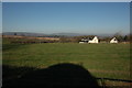
1
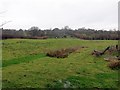
Gully, Woonton Ash
A wide gully in a field, sometimes these are old trackways.
Image: © Richard Webb
Taken: 15 Feb 2014
0.08 miles
2
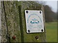
Footpath sign
A bit of a collector's item. Hereford and Worcester council spent very little on Herefordshire's footpath network which was then largely unusable. Most of the budget was spent in Worcestershire.
Image: © Richard Webb
Taken: 15 Feb 2014
0.09 miles