IMAGES TAKEN NEAR TO
Lyonshall, KINGTON, HR5 3HZ
Introduction
This page details the photographs taken nearby to HR5 3HZ by members of the Geograph project.
The Geograph project started in 2005 with the aim of publishing, organising and preserving representative images for every square kilometre of Great Britain, Ireland and the Isle of Man.

There are currently over 7.5m images from over14,400 individuals and you can help contribute to the project by visiting https://www.geograph.org.uk
Image Map
Images are licensed for reuse under creativecommons.org/licenses/by-sa/2.0
Notes
- Clicking on the map will re-center to the selected point.
- The higher the marker number, the further away the image location is from the centre of the postcode.
Image Listing (13 Images Found)
Images are licensed for reuse under creativecommons.org/licenses/by-sa/2.0
Image
Details
Distance
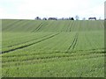
4
Night Watch
A notice board near Lyonshall.
Image: © Richard Webb
Taken: 9 Aug 2013
0.19 miles
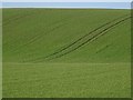
5
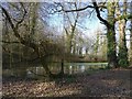
Pond, The Whitern
An elongated rectangular pond.
Image: © Richard Webb
Taken: 14 Feb 2019
0.20 miles
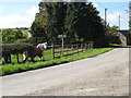
6
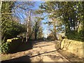
Road junction, The Whittern
Roads left and right, straight on for the pond.
Image: © Richard Webb
Taken: 14 Feb 2019
0.20 miles
7
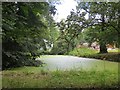
Pond, Next End
A long rectangular pond, covered in duckweed.
Image: © Richard Webb
Taken: 9 Aug 2013
0.20 miles
8
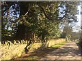
Sequoia, The Wittern
Some specimen trees here, with a fine oak avenue further down the road.
Image: © Richard Webb
Taken: 14 Feb 2019
0.21 miles
10
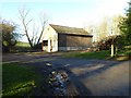
A barn and timber stacks
A barn and timber stacks at Lewis Wych.
Image: © Philip Halling
Taken: 2 Feb 2018
0.22 miles