IMAGES TAKEN NEAR TO
Sutton Walls Grove, KINGTON, HR5 3GH
Introduction
This page details the photographs taken nearby to Sutton Walls Grove, HR5 3GH by members of the Geograph project.
The Geograph project started in 2005 with the aim of publishing, organising and preserving representative images for every square kilometre of Great Britain, Ireland and the Isle of Man.

There are currently over 7.5m images from over14,400 individuals and you can help contribute to the project by visiting https://www.geograph.org.uk
Image Map
Images are licensed for reuse under creativecommons.org/licenses/by-sa/2.0
Notes
- Clicking on the map will re-center to the selected point.
- The higher the marker number, the further away the image location is from the centre of the postcode.
Image Listing (40 Images Found)
Images are licensed for reuse under creativecommons.org/licenses/by-sa/2.0
Image
Details
Distance
1
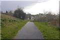
Informal recreation area, Kington
Path in a patch of land amongst new houses.
Image: © Richard Webb
Taken: 2 Apr 2019
0.04 miles
2
Headbrook, Kington
Junction of Headbrook and Old Eardisley Road.
Image: © Richard Webb
Taken: 2 Apr 2019
0.08 miles
3
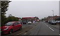
Texaco filling station, Headbrook, Kington
Image: © David Smith
Taken: 19 Oct 2017
0.08 miles
4
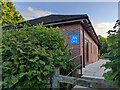
Kingdom Hall of Jehovah's Witnesses (Kington)
This brick building is situated south of the town of Kington, and according to the Hereford Times, this was built in May 2008 in four days.
This was taken on a visit to the Brian Kemp Building south of this building, named after my late maternal grandfather. It houses one of the buildings at Kington Farm Supplies.
Image: © Fabian Musto
Taken: 10 Jun 2022
0.11 miles
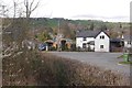
5
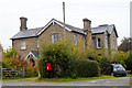
Former Drill Hall, Kington
Large rock-faced building in Headbrook, now converted to a very large house. Still occupied but slowly disappearing beneath vegetation.
Image: © Philip Pankhurst
Taken: 12 Oct 2014
0.12 miles
6
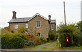
Former Drill Hall, Kington
Large rock-faced building in Headbrook, now converted to a very large house. Still occupied but slowly disappearing beneath vegetation.
Image: © Philip Pankhurst
Taken: 12 Oct 2014
0.12 miles
7
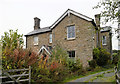
Former Drill Hall, Kington
Large rock-faced building in Headbrook, now converted to a very large house. Still occupied but slowly disappearing beneath vegetation.
Image: © Philip Pankhurst
Taken: 12 Oct 2014
0.12 miles
8
The Brian Kemp Building (Kington)
I visited this building in tribute of my late maternal grandfather, who passed away on the same day this photograph was taken. This building, built in the 2010s, houses one of the buildings at Kington Farm Supplies, a farm shop situated by the A4111 road. Brian Kemp (b. 23rd September 1945) was the manager of Burgess for many years (the predecessor of Kington Farm Supplies).
Image: © Fabian Musto
Taken: 10 Jun 2022
0.14 miles
9
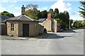
The Old Toll House
An early 19th century former Toll House on the road into Kington. The house is Grade II listed, see: https://historicengland.org.uk/listing/the-list/list-entry/1208007?section=official-list-entry
Image: © Philip Halling
Taken: 23 Sep 2022
0.14 miles
10
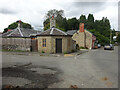
Toll House, Kington
"The Old Toll House", on the corner of Headbrook, Bridge Street and Townsend. Listed in 1976 but the restoration looks much newer (pre 2002 at least). A local reported that it was a ruin in the late 1950s/early 60s because he recalled playing in it. Looking closely at the chimney stack with traces of white paint, that must be original. Erected by the Kington Turnpike Trust in the 19ᵗʰ C. More local toll houses see https://www.geograph.org.uk/discuss/index.php?&action=vthread&forum=11&topic=33104
Grade II Listed, No. 1208007 https://historicengland.org.uk/listing/the-list/list-entry/1208007
Milestone Society National ID: HF.KIN02
Image: © Mr Red
Taken: 9 Sep 2022
0.15 miles