IMAGES TAKEN NEAR TO
Orchard Rise, KINGTON, HR5 3FH
Introduction
This page details the photographs taken nearby to Orchard Rise, HR5 3FH by members of the Geograph project.
The Geograph project started in 2005 with the aim of publishing, organising and preserving representative images for every square kilometre of Great Britain, Ireland and the Isle of Man.

There are currently over 7.5m images from over14,400 individuals and you can help contribute to the project by visiting https://www.geograph.org.uk
Image Map (Loading...)


Getting Data...Please wait
Leaflet Map data © OpenStreetMap
Images are licensed for reuse under creativecommons.org/licenses/by-sa/2.0
Notes
- Clicking on the map will re-center to the selected point.
- The higher the marker number, the further away the image location is from the centre of the postcode.
Image Listing (285 Images Found)
Images are licensed for reuse under creativecommons.org/licenses/by-sa/2.0
Image
Details
Distance
3
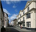
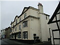
The Oxford Arms, looking west
The Oxford Arms is a large hostelry on Duke Street which would have been the main route through town at one time.
The large truck approaching at the end of the street shows how impossible this would be for today's traffic.
Image: © Des Blenkinsopp
Taken: 24 Jun 2014
0.10 miles
4
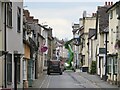
Duke Street, Kington
The street was closed as a post-Covid government fund is paying to spruce up the frontages of its many fascinating and beautiful old buildings.
Image: © Mike Parker
Taken: 28 Apr 2022
0.10 miles
5
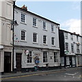
The Oxford Arms Hotel, Kington
Dates from the eighteenth century https://historicengland.org.uk/listing/the-list/list-entry/1293179?section=official-list-entry
Image: © Jonathan Thacker
Taken: 22 Aug 2022
0.10 miles
6
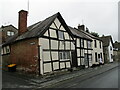
Duke Street, Kington
No 41., closest to the camera and No. 40 adjacent, date to the late sixteenth century https://historicengland.org.uk/listing/the-list/list-entry/1293174?section=official-list-entry
Image: © Jonathan Thacker
Taken: 22 Aug 2022
0.10 miles
7
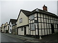
Duke Street, Kington
Parts of the house closest to the camera date to the fifteenth century https://historicengland.org.uk/listing/the-list/list-entry/1196535?section=official-list-entry
Image: © Jonathan Thacker
Taken: 22 Aug 2022
0.11 miles
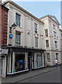
8
HSBC Kington
Bank branch at 1 High Street, opposite Bridge Street. A plaque http://www.geograph.org.uk/photo/3534857 on the wall records that the branch was formerly the Kington & Radnorshire Bank, established in 1808.
Image: © Jaggery
Taken: 26 Jun 2013
0.11 miles
9
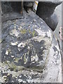
Ordnance Survey Rivet
This OS rivet can be found on the stone at the junction of Duke Street. It marks a point 156.987m above mean sea level.
Image: © Adrian Dust
Taken: 19 Nov 2015
0.11 miles
10
Barclays Bank, Kington
Bank branch at 4 High Street, near the Bridge Street junction.
Image: © Jaggery
Taken: 26 Jun 2013
0.11 miles