IMAGES TAKEN NEAR TO
Market Hall Street, KINGTON, HR5 3DP
Introduction
This page details the photographs taken nearby to Market Hall Street, HR5 3DP by members of the Geograph project.
The Geograph project started in 2005 with the aim of publishing, organising and preserving representative images for every square kilometre of Great Britain, Ireland and the Isle of Man.

There are currently over 7.5m images from over14,400 individuals and you can help contribute to the project by visiting https://www.geograph.org.uk
Image Map
Images are licensed for reuse under creativecommons.org/licenses/by-sa/2.0
Notes
- Clicking on the map will re-center to the selected point.
- The higher the marker number, the further away the image location is from the centre of the postcode.
Image Listing (290 Images Found)
Images are licensed for reuse under creativecommons.org/licenses/by-sa/2.0
Image
Details
Distance
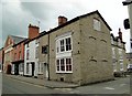
2
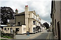
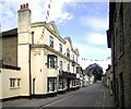
The Oxford Arms, Kington
Slightly off the beaten track in Duke Street
Image: © Philip Pankhurst
Taken: 6 Jun 2010
0.02 miles
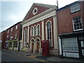
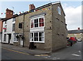
3

Library, Lower Cross
Lower Cross is the name given to the area around the junction of Duke Street (formerly Duck Street) straight ahead, High Street behind the camera and Bridge Street to the right.
The Kington Centre (or library on the maps) was built in 1905 for The Old Radnor Lime, Roadstone and General Trading Company.
The Grade II, two-storey building is of Classical design with balustraded parapet and modillioned cornice; the entrance is surmounted by a pediment, and the windows by segmental arches with keyblocks.
The building is constructed of precast concrete made to resemble granite, with ashlar finish to the first floor.
Image: © Bob Embleton
Taken: 27 Feb 2010
0.03 miles
4
Kington Baptist Church
Placed on Bridge Street is the Baptist church at Kington, which was built in 1868. In front of the majestic building is a K6 telephone box; both of these are grade II listed.
Image: © Fabian Musto
Taken: 30 Jun 2020
0.03 miles
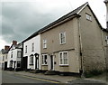
5
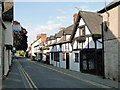
The Old House, Duke Street, Kington
One of the many timber framed houses that line the streets of this border town.
Image: © Philip Pankhurst
Taken: 26 Jun 2010
0.04 miles
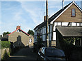
6
The Oxford Arms, looking east
A view along Duke Street.
Image: © Des Blenkinsopp
Taken: 22 Jun 2014
0.04 miles
7
A selection of doorsteps, Bridge Street
Image: © Philip Pankhurst
Taken: 6 Jun 2010
0.04 miles
8
The Lion Restaurant, Kington
Located in Bridge Street on the corner of Market Hall Street.
Formerly the Lion Hotel. http://www.geograph.org.uk/photo/1913560
Image: © Jaggery
Taken: 26 Jun 2013
0.04 miles
9
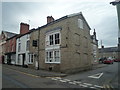
The Lion Hotel (Kington)
Formerly the Talbot Hotel, this stone building in Bridge Street was built in the 19th century to a 17th century core; this also houses a restaurant.
Image: © Fabian Musto
Taken: 30 Jun 2020
0.04 miles
10
Lion Hotel, Kington
In Bridge Street, just down from the Baptist Church.
Image: © Philip Pankhurst
Taken: 6 Jun 2010
0.04 miles