IMAGES TAKEN NEAR TO
Belle Bank Avenue, HEREFORD, HR4 9RL
Introduction
This page details the photographs taken nearby to Belle Bank Avenue, HR4 9RL by members of the Geograph project.
The Geograph project started in 2005 with the aim of publishing, organising and preserving representative images for every square kilometre of Great Britain, Ireland and the Isle of Man.

There are currently over 7.5m images from over14,400 individuals and you can help contribute to the project by visiting https://www.geograph.org.uk
Image Map
Images are licensed for reuse under creativecommons.org/licenses/by-sa/2.0
Notes
- Clicking on the map will re-center to the selected point.
- The higher the marker number, the further away the image location is from the centre of the postcode.
Image Listing (71 Images Found)
Images are licensed for reuse under creativecommons.org/licenses/by-sa/2.0
Image
Details
Distance
1
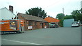
Wood Burning Stoves (Holmer)
Viewed from the A49 road. Nothing much to say here.
Image: © Fabian Musto
Taken: 23 May 2018
0.03 miles
2
The Cider House (Holmer)
The Crossways (formerly Cross House) next door neighbour. This looks like this was built in either the 20th century or late 19th century.
Image: © Fabian Musto
Taken: 23 May 2018
0.05 miles
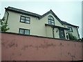
4
The Crossways (Holmer)
A photo I took of The Crossways two months ago, before the site was completely blocked up by a brick wall.
Image: © Fabian Musto
Taken: 18 Apr 2018
0.05 miles
5
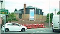
The Crossways (Holmer)
Former site: Image
As of 20th June 2018, The Crossways looks almost complete now!
Image: © Fabian Musto
Taken: 20 Jun 2018
0.05 miles

7

Starting Gate roundabout
A49 crosses the A4103.
Image: © Pauline E
Taken: 18 Nov 2008
0.06 miles
8
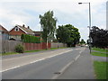
The A49 Road (Holmer)
The last photo I'll upload on Geograph with the terrible "green-coloured" effect on my new camera. Don't know why I had it first enabled, but luckily I fixed it now. Anyways, here is the A49 road at Holmer, which looks quite quiet. Compare this to the morning on weekdays!
Image: © Fabian Musto
Taken: 26 Apr 2018
0.06 miles
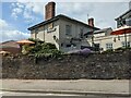
9
Cross House (Holmer)
I took this picture a few weeks prior to its demolition. Looks like an average Victorian house you would see as always, but at this time when I took this, it was derelict. The new houses are almost complete, so I might take a picture of them when they are finished.
Link to current site: http://www.geograph.org.uk/photo/5738755
Image: © Fabian Musto
Taken: 7 Mar 2017
0.06 miles
10
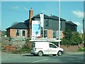
Beefeater (Holmer)
Placed by the A49 road is this steak house, known as Starting Gate Beefeater. I miss seeing their 2009-15 logo on the building, but the 2015-present logo looks alright to me. I heard this building housed a pub during the 19th-20th centuries.
Image: © Fabian Musto
Taken: 29 Apr 2021
0.07 miles