IMAGES TAKEN NEAR TO
Tillington, HEREFORD, HR4 8LH
Introduction
This page details the photographs taken nearby to HR4 8LH by members of the Geograph project.
The Geograph project started in 2005 with the aim of publishing, organising and preserving representative images for every square kilometre of Great Britain, Ireland and the Isle of Man.

There are currently over 7.5m images from over14,400 individuals and you can help contribute to the project by visiting https://www.geograph.org.uk
Image Map
Images are licensed for reuse under creativecommons.org/licenses/by-sa/2.0
Notes
- Clicking on the map will re-center to the selected point.
- The higher the marker number, the further away the image location is from the centre of the postcode.
Image Listing (7 Images Found)
Images are licensed for reuse under creativecommons.org/licenses/by-sa/2.0
Image
Details
Distance
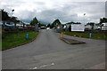
3

Harvested maize field, Tillington
The stubble remains of a field of maize near Tillington.
Image: © Philip Halling
Taken: 9 Jan 2011
0.17 miles
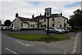
5
Village shop at Tillington
More than the average village shop, this one also sells cars.
Image: © Philip Halling
Taken: 16 Jun 2007
0.20 miles
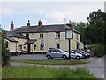
6
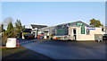
Tillington village store
The business also serves the adjoining caravan site and does garage services too.
Image: © Jonathan Billinger
Taken: 20 Dec 2013
0.21 miles
7
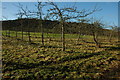
Trees on golf course edge
Trees on the edge of a golf course near Tillington.
Image: © Philip Halling
Taken: 9 Jan 2011
0.25 miles