IMAGES TAKEN NEAR TO
Wellington, HEREFORD, HR4 8DX
Introduction
This page details the photographs taken nearby to HR4 8DX by members of the Geograph project.
The Geograph project started in 2005 with the aim of publishing, organising and preserving representative images for every square kilometre of Great Britain, Ireland and the Isle of Man.

There are currently over 7.5m images from over14,400 individuals and you can help contribute to the project by visiting https://www.geograph.org.uk
Image Map
Images are licensed for reuse under creativecommons.org/licenses/by-sa/2.0
Notes
- Clicking on the map will re-center to the selected point.
- The higher the marker number, the further away the image location is from the centre of the postcode.
Image Listing (19 Images Found)
Images are licensed for reuse under creativecommons.org/licenses/by-sa/2.0
Image
Details
Distance
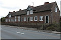
1
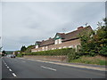
Almshouses at Wellington, Herefordshire
Victorian almshouses beside the road.
Image: © Jeremy Bolwell
Taken: 1 Sep 2013
0.01 miles
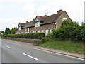
3
Almshouses at Wellington
These almshouses are situated on the busy A49. The inscription on the building states that the almshouses were founded and endowed by Sir Herbert Perrott in 1682 and restored for Queen Victoria's Jubilee in 1887.
Image: © Philip Halling
Taken: 31 Mar 2006
0.03 miles
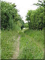
4

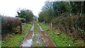
Track (footpath) off the A49
The footpath goes to Marden.
Image: © JThomas
Taken: 2 Nov 2019
0.04 miles
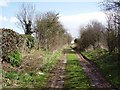
5
Green Lane to Marden
A bit squidgy in this very wet winter.
Image: © Jonathan Billinger
Taken: 5 Jan 2016
0.04 miles
6
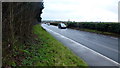
A49 near Wellington
Looking south towards Hereford; the easting gridline follows the hedge on the other side of the road.
Image: © Jonathan Billinger
Taken: 5 Jan 2016
0.05 miles
7
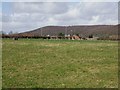
Towards Wellington.
NW view across the northeastern corner of the square with the football pitch being about on the other boundary. Wellington has quite a successful team.
Image: © Richard Webb
Taken: 1 Apr 2006
0.08 miles
8
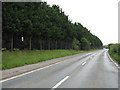
Ordnance Depot Fencing
The site of the former ordnance depot, now a Business Park, is still screened from view on this section of the A49.
Image: © Peter Whatley
Taken: 29 Jun 2009
0.08 miles
9
Green lane, Wellington.
Heading east, now carrying a footpath. Taken from near the Almshouses beside the A49.
Image: © Richard Webb
Taken: 1 Apr 2006
0.08 miles