IMAGES TAKEN NEAR TO
Moreton-on-Lugg, HEREFORD, HR4 8DR
Introduction
This page details the photographs taken nearby to HR4 8DR by members of the Geograph project.
The Geograph project started in 2005 with the aim of publishing, organising and preserving representative images for every square kilometre of Great Britain, Ireland and the Isle of Man.

There are currently over 7.5m images from over14,400 individuals and you can help contribute to the project by visiting https://www.geograph.org.uk
Image Map
Images are licensed for reuse under creativecommons.org/licenses/by-sa/2.0
Notes
- Clicking on the map will re-center to the selected point.
- The higher the marker number, the further away the image location is from the centre of the postcode.
Image Listing (24 Images Found)
Images are licensed for reuse under creativecommons.org/licenses/by-sa/2.0
Image
Details
Distance


5
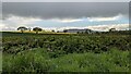
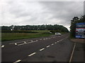
Countryside by Moreton Business Park
There was traffic on the A49 road, so I took this viewpoint looking north from the road while waiting.
Image: © Fabian Musto
Taken: 10 May 2021
0.07 miles
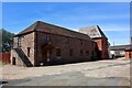
7
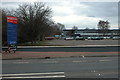
Moreton Business Park
The Moreton Business Park viewed from the A49.
Image: © Philip Halling
Taken: 31 Mar 2006
0.11 miles
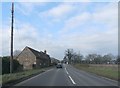
8
Outside Moreton Business Park on the A49
Image: © Basher Eyre
Taken: 23 Jun 2024
0.11 miles
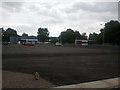
9
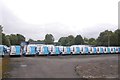
Connects vans
Parked up on the Royal Army Ordnance Corps site at Moreton on Lugg. The Army have now left and the site is now industrial.
Image: © Richard Webb
Taken: 19 Jul 2019
0.12 miles
10
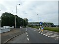
A49 near Moreton-on-Lugg, looking north
Image: © Rob Purvis
Taken: 21 Jun 2011
0.14 miles