IMAGES TAKEN NEAR TO
Lyde, HEREFORD, HR4 8AB
Introduction
This page details the photographs taken nearby to HR4 8AB by members of the Geograph project.
The Geograph project started in 2005 with the aim of publishing, organising and preserving representative images for every square kilometre of Great Britain, Ireland and the Isle of Man.

There are currently over 7.5m images from over14,400 individuals and you can help contribute to the project by visiting https://www.geograph.org.uk
Image Map
Images are licensed for reuse under creativecommons.org/licenses/by-sa/2.0
Notes
- Clicking on the map will re-center to the selected point.
- The higher the marker number, the further away the image location is from the centre of the postcode.
Image Listing (6 Images Found)
Images are licensed for reuse under creativecommons.org/licenses/by-sa/2.0
Image
Details
Distance
1
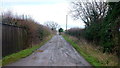
Public track towards Lower Lyde Court
Unseen to the left is Hill Barn.
Image: © Jonathan Billinger
Taken: 5 Jan 2016
0.11 miles
2
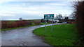
Driving Range
Or as it confidently announces on the sign; Herefordshire Golf Academy.
Image: © Jonathan Billinger
Taken: 5 Jan 2016
0.11 miles
5
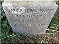
Geographical Centre of Herefordshire
A stone marking the geographical centre of Herefordshire. It reads: THESE TREES WERE PLANTED BY WILLIAM JAY AND A FEW FRIENDS TO MARK THE CENTRE OF THE COUNTY APRIL 1857
Image: © Pebble
Taken: 25 Jun 2022
0.24 miles