IMAGES TAKEN NEAR TO
Breinton, HEREFORD, HR4 7PQ
Introduction
This page details the photographs taken nearby to HR4 7PQ by members of the Geograph project.
The Geograph project started in 2005 with the aim of publishing, organising and preserving representative images for every square kilometre of Great Britain, Ireland and the Isle of Man.

There are currently over 7.5m images from over14,400 individuals and you can help contribute to the project by visiting https://www.geograph.org.uk
Image Map
Images are licensed for reuse under creativecommons.org/licenses/by-sa/2.0
Notes
- Clicking on the map will re-center to the selected point.
- The higher the marker number, the further away the image location is from the centre of the postcode.
Image Listing (3 Images Found)
Images are licensed for reuse under creativecommons.org/licenses/by-sa/2.0
Image
Details
Distance
1
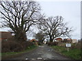
Upper Hill Farm
A bridleway runs north from here, through the farm, to meet the King's Acre Road west of Hereford.
Image: © Jonathan Billinger
Taken: 12 Mar 2007
0.13 miles
2
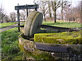
Cider Press Little Breinton Farm
This cider press,presumably it was a two stage process is by the roadside adjacent to the farm entrance. The farm is surrounded by cider orchards.
Image: © Richard Greenwood
Taken: 8 Mar 2007
0.19 miles
3

Lane at Little Breinton Farm
Upper Hill Farm buildings to the right of the cider press.
Image: © Trevor Rickard
Taken: 17 Mar 2007
0.20 miles