IMAGES TAKEN NEAR TO
Bridge Sollars, HEREFORD, HR4 7JW
Introduction
This page details the photographs taken nearby to HR4 7JW by members of the Geograph project.
The Geograph project started in 2005 with the aim of publishing, organising and preserving representative images for every square kilometre of Great Britain, Ireland and the Isle of Man.

There are currently over 7.5m images from over14,400 individuals and you can help contribute to the project by visiting https://www.geograph.org.uk
Image Map
Images are licensed for reuse under creativecommons.org/licenses/by-sa/2.0
Notes
- Clicking on the map will re-center to the selected point.
- The higher the marker number, the further away the image location is from the centre of the postcode.
Image Listing (3 Images Found)
Images are licensed for reuse under creativecommons.org/licenses/by-sa/2.0
Image
Details
Distance
1
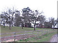
Marsh Court
The farm sits on its wooded hill within a loop of the River Wye.
Image: © Jonathan Billinger
Taken: 12 Mar 2007
0.07 miles
2
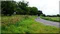
Road to Marsh Court
Taken over five years since the first photograph for this square, and by the same photographer.
Image
Image: © Jonathan Billinger
Taken: 16 Aug 2012
0.12 miles
3
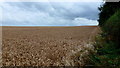
Wheat field by Marsh Court
It's mid-August so this field should soon be in line for harvesting, weather-permitting!
Image: © Jonathan Billinger
Taken: 16 Aug 2012
0.13 miles