IMAGES TAKEN NEAR TO
St. Davids Road, HEREFORD, HR4 7DQ
Introduction
This page details the photographs taken nearby to St. Davids Road, HR4 7DQ by members of the Geograph project.
The Geograph project started in 2005 with the aim of publishing, organising and preserving representative images for every square kilometre of Great Britain, Ireland and the Isle of Man.

There are currently over 7.5m images from over14,400 individuals and you can help contribute to the project by visiting https://www.geograph.org.uk
Image Map
Images are licensed for reuse under creativecommons.org/licenses/by-sa/2.0
Notes
- Clicking on the map will re-center to the selected point.
- The higher the marker number, the further away the image location is from the centre of the postcode.
Image Listing (7 Images Found)
Images are licensed for reuse under creativecommons.org/licenses/by-sa/2.0
Image
Details
Distance
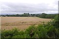
2
Winter cereal at Credenhill
A field of winter cereal opposite the car park and picnic site which provides access to Credenhill.
Image: © Philip Halling
Taken: 9 Jan 2011
0.20 miles
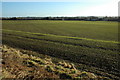
3
Wheat, Credenhill
A field between the village and the Credenhill Park Woods.
Image: © Richard Webb
Taken: 19 Jul 2019
0.21 miles
5
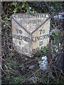
Old Milepost by the A480, Credenhill
Cast iron post by the A480, in parish of Credenhill (District), East of RAF Hereford, in hedge bank, on North side of road. Erected by the Hereford turnpike trust in the 19th century.
Inscription reads:-
: TO / HEREFORD / 4 / MILES : : CREDENHILL / PARISH : : TO / KINGTON / 15 / MILES :
Herefordshire SMR.
SMR Number: 56601 https://www.heritagegateway.org.uk/Gateway/Results_Single.aspx?uid=MHE28357&resourceID=101
Milestone Society National ID: HF_HFKG04
Image: © Robert Walker
Taken: 24 Jan 2013
0.23 miles
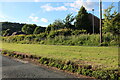
6
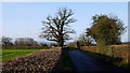
Road to Credenhill
Part of the village's army housing can be seen over the hedge to the left.
Image: © Jonathan Billinger
Taken: 20 Dec 2013
0.25 miles
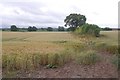
7
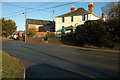
Houses at Credenhill
Houses beside the A480 near Credenhill.
Image: © Philip Halling
Taken: 9 Jan 2011
0.25 miles