IMAGES TAKEN NEAR TO
Yazor, HEREFORD, HR4 7BA
Introduction
This page details the photographs taken nearby to HR4 7BA by members of the Geograph project.
The Geograph project started in 2005 with the aim of publishing, organising and preserving representative images for every square kilometre of Great Britain, Ireland and the Isle of Man.

There are currently over 7.5m images from over14,400 individuals and you can help contribute to the project by visiting https://www.geograph.org.uk
Image Map
Images are licensed for reuse under creativecommons.org/licenses/by-sa/2.0
Notes
- Clicking on the map will re-center to the selected point.
- The higher the marker number, the further away the image location is from the centre of the postcode.
Image Listing (129 Images Found)
Images are licensed for reuse under creativecommons.org/licenses/by-sa/2.0
Image
Details
Distance
1
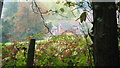
The Old Vicarage & Old School (Yazor)
Here is the old vicarage (centre-left) and old school (centre-right) at Yazor, which this is viewed from a lane that leads up to the settlement of Yarsop.
Image: © Fabian Musto
Taken: 20 Oct 2018
0.00 miles
2
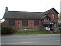
The Old School (Yazor)
Here is the old School at Yazor, which this structure looks very nice, as the timbers blend in well with the brick material behind it. The A480 road is in front.
Image: © Fabian Musto
Taken: 20 Oct 2018
0.01 miles
3
The Old Vicarage (Yazor)
Here is the old vicarage at Yazor, which this might have been used as the vicarage for this forlorn church: Image | The A480 road is in front of this building.
Image: © Fabian Musto
Taken: 20 Oct 2018
0.01 miles
4
The A480 Road (Yazor)
The A480 road passes straight through the small village of Yazor in Herefordshire, and sometimes the road could be very thunderous.
Image: © Fabian Musto
Taken: 20 Oct 2018
0.02 miles
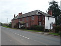
5
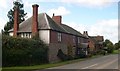
Old Vicarage, Yazor
With the former village school, I believe, next door.
Image: © Philip Pankhurst
Taken: 8 Oct 2008
0.02 miles
6
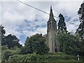
St. Mary's church (Yazor)
Here is St. Mary's parish church in Yazor, placed close to the A480 road. This was built in 1843 by George Moore, and a spire was added on top eight years later. The church closed for worship in 1986, and the Churches Conservation Trust has managed the church since then.
Image: © Fabian Musto
Taken: 6 Jul 2021
0.07 miles
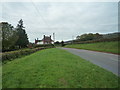
7
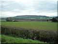
Yazor Hill
Here is Yazor Hill, which this is viewed from a piece of grassland by the A480 road.
Image: © Fabian Musto
Taken: 20 Oct 2018
0.07 miles
8
Former St. John the Baptist church (Yazor)
Built around the 14th and 15th centuries, the former parish church of St. John the Baptist was mainly demolished from c.1843-c.1855, although the south transept and bell tower buildings were retained, the former of which was restored in 1858.
Image: © Fabian Musto
Taken: 6 Jul 2021
0.07 miles
9
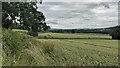
Field by the A480 road (Yazor)
This field has a nice countryside view in the distance.
Image: © Fabian Musto
Taken: 6 Jul 2021
0.07 miles
10
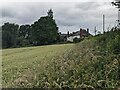
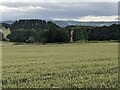
Field by the A480 road (Yazor)
The building closest to the camera is the old vicarage, built around the 19th century.
Image: © Fabian Musto
Taken: 6 Jul 2021
0.07 miles