IMAGES TAKEN NEAR TO
Kinnersley, HEREFORD, HR3 6QE
Introduction
This page details the photographs taken nearby to HR3 6QE by members of the Geograph project.
The Geograph project started in 2005 with the aim of publishing, organising and preserving representative images for every square kilometre of Great Britain, Ireland and the Isle of Man.

There are currently over 7.5m images from over14,400 individuals and you can help contribute to the project by visiting https://www.geograph.org.uk
Image Map (Loading...)


Getting Data...Please wait
Leaflet Map data © OpenStreetMap
Images are licensed for reuse under creativecommons.org/licenses/by-sa/2.0
Notes
- Clicking on the map will re-center to the selected point.
- The higher the marker number, the further away the image location is from the centre of the postcode.
Image Listing (9 Images Found)
Images are licensed for reuse under creativecommons.org/licenses/by-sa/2.0
Image
Details
Distance
1
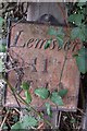
Old Milepost by the A4112, Sallys Farm, Kinnersley
Metal plate attached to wooden post by the A4112, in parish of Kinnersley (District), Sallys Farm (Sallies), in hedge, on North side of road. Parton Stone, erected by the Monkland & Parton turnpike trust in the 19th century.
Inscription reads:-
Lemster
11
Miles
Grade II listed.
List Entry Number: 1157652 https://historicengland.org.uk/listing/the-list/list-entry/1157652
Milestone Society National ID: HF_LMHY11
Image: © J Higgins
Taken: 1 Oct 2006
0.10 miles
2

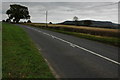
Early daffodils beside the A4112 at Sallys
Image: © Philip Halling
Taken: 3 Feb 2007
0.10 miles
3
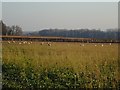
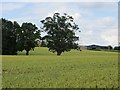
Sheep on turnips, Sallys
Strip grazing in very dry conditions. February 2019 was strange.
Image: © Richard Webb
Taken: 14 Feb 2019
0.11 miles
4
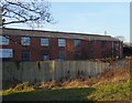
Sallies Mill Eco Logistics
Mapped as a saw mill, industrial building beside the A4112.
Image: © Richard Webb
Taken: 14 Feb 2019
0.16 miles
5
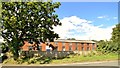
Sallies Mill, Kinnersley
A former saw mill and timber yard which has seen a number of uses since closure. Present venture not looking to lively as the gates were locked and no one was at home.
Image: © Philip Pankhurst
Taken: 9 Sep 2013
0.16 miles
7
Wheat, Hallaston
Beside the Leominster to Hay road.
Image: © Richard Webb
Taken: 29 Jun 2014
0.21 miles
8
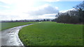
Farm road to The Parks
The tarmac road is a private drive to Parks Farm.
Image: © Jonathan Billinger
Taken: 10 Feb 2016
0.22 miles
9
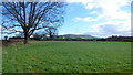
Farmland and bridleway
Not much evidence of a path in this tidily-managed farmland near Parks Farm.
Burton/Ladylift Hill (290m) is in the distance.
Image: © Jonathan Billinger
Taken: 10 Feb 2016
0.23 miles