IMAGES TAKEN NEAR TO
Eardisley, HEREFORD, HR3 6NS
Introduction
This page details the photographs taken nearby to HR3 6NS by members of the Geograph project.
The Geograph project started in 2005 with the aim of publishing, organising and preserving representative images for every square kilometre of Great Britain, Ireland and the Isle of Man.

There are currently over 7.5m images from over14,400 individuals and you can help contribute to the project by visiting https://www.geograph.org.uk
Image Map
Images are licensed for reuse under creativecommons.org/licenses/by-sa/2.0
Notes
- Clicking on the map will re-center to the selected point.
- The higher the marker number, the further away the image location is from the centre of the postcode.
Image Listing (180 Images Found)
Images are licensed for reuse under creativecommons.org/licenses/by-sa/2.0
Image
Details
Distance
1
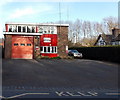
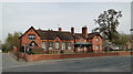
Eardisley Fire Station
Viewed across the A4111 near the corner of Lady Gardens. Eardisley Fire Station is part of the Hereford & Worcester Fire and Rescue Service. The station has one on-call fire engine and twelve firefighters, all volunteers who live or work locally and can reach the fire station within 5 minutes of an alarm being raised. The station is responsible for a mainly rural area within a roughly 7 mile (c11km) radius from the station. The firefighters can also be called to assist at major incidents anywhere in Herefordshire or Worcestershire.
Image: © Jaggery
Taken: 19 Mar 2014
0.03 miles
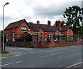
2
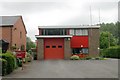
Eardisley Fire Station
Eardisley Fire Station, Kington Road, Eardisley forms part of the Hereford & Worcester Fire Brigade
Image: © Kevin Hale
Taken: 3 Jun 2007
0.04 miles
3
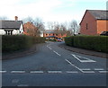
Lady Gardens, Eardisley
A cul-de-sac on the east side of the A4111, near the fire station. http://www.geograph.org.uk/photo/3894013
Image: © Jaggery
Taken: 19 Mar 2014
0.05 miles
4

Wide white gates, Eardisley
Across the A4111 end of the entrance drive to Eardisley House.
Image: © Jaggery
Taken: 19 Mar 2014
0.05 miles
5
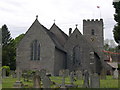
St Mary Magdalene's Church, Eardisley
Image: © Philip Pankhurst
Taken: 8 May 2007
0.06 miles
6
Primary School, Eardisley
Thriving solid Victorian village school - opposite the parish church.
Image: © Philip Pankhurst
Taken: 24 Apr 2010
0.07 miles
7
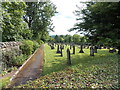
Graveyard, Eardisley
The burial ground is located to the SW of the village church http://www.geograph.org.uk/photo/3529480 and churchyard.
Image: © Jaggery
Taken: 26 Jun 2013
0.08 miles
8

Daffodils at the edge of the churchyard, Eardisley
Looking across the A4111 Church Road towards the Parish Church of Saint Mary Magdalene in mid March 2014.
Image: © Jaggery
Taken: 19 Mar 2014
0.08 miles
9
Eardisley CE Primary School
The village primary school is on the corner of the A4111 Church Road and the road leading to Orchard Close and Lower Castle Farm. The CE in the name is short for Church of England. There are about 75 pupils enrolled, ages 4-11.
Image: © Jaggery
Taken: 26 Jun 2013
0.09 miles
10
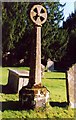
Restored Preaching Cross in Eardisley Churchyard
Image: © paul wood
Taken: 27 Jan 2004
0.09 miles