IMAGES TAKEN NEAR TO
Eardisley, HEREFORD, HR3 6LY
Introduction
This page details the photographs taken nearby to HR3 6LY by members of the Geograph project.
The Geograph project started in 2005 with the aim of publishing, organising and preserving representative images for every square kilometre of Great Britain, Ireland and the Isle of Man.

There are currently over 7.5m images from over14,400 individuals and you can help contribute to the project by visiting https://www.geograph.org.uk
Image Map
Images are licensed for reuse under creativecommons.org/licenses/by-sa/2.0
Notes
- Clicking on the map will re-center to the selected point.
- The higher the marker number, the further away the image location is from the centre of the postcode.
Image Listing (7 Images Found)
Images are licensed for reuse under creativecommons.org/licenses/by-sa/2.0
Image
Details
Distance
1
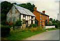
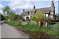
Former smithy and New House, Wood Eaves, Eardisley
The timber-framed building has been a smithy according to the listing details, and was converted to a cottage in the 19C. Street View, in 2009, shows it stripped to its timbers and with the preparations made for a new tile roof.
Image: © Humphrey Bolton
Taken: 5 Jul 1999
0.01 miles
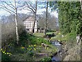
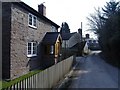
2
Black and white cottage, at Woods Eaves
Image: © Roger Cornfoot
Taken: 24 Mar 2007
0.06 miles
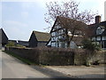
3
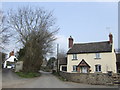
Woods Eaves
A hamlet with a name possibly referring to its past economy derived from woodland activity.
Image: © Jonathan Billinger
Taken: 26 Mar 2007
0.06 miles
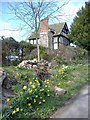
4
Stream at Woods Eaves
Passes through an idyllic garden setting.
Image: © Roger Cornfoot
Taken: 24 Mar 2007
0.07 miles
5
Cottage in Wood Eaves
Timber-frame cottage in Wood Eaves.
Image: © Philip Halling
Taken: 5 May 2012
0.10 miles
6
Woods Eaves
A small hamlet, between Eardisley and Whitney.
Image: © Roger Cornfoot
Taken: 24 Mar 2007
0.15 miles
7
Woods Eaves Farm
One of the many black-and-white buildings hereabout.
Image: © Jonathan Billinger
Taken: 26 Mar 2007
0.25 miles