IMAGES TAKEN NEAR TO
Brilley, Whitney-on-Wye, HEREFORD, HR3 6JN
Introduction
This page details the photographs taken nearby to HR3 6JN by members of the Geograph project.
The Geograph project started in 2005 with the aim of publishing, organising and preserving representative images for every square kilometre of Great Britain, Ireland and the Isle of Man.

There are currently over 7.5m images from over14,400 individuals and you can help contribute to the project by visiting https://www.geograph.org.uk
Image Map (Loading...)


Getting Data...Please wait
Leaflet Map data © OpenStreetMap
Images are licensed for reuse under creativecommons.org/licenses/by-sa/2.0
Notes
- Clicking on the map will re-center to the selected point.
- The higher the marker number, the further away the image location is from the centre of the postcode.
Image Listing (6 Images Found)
Images are licensed for reuse under creativecommons.org/licenses/by-sa/2.0
Image
Details
Distance
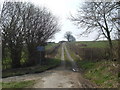
2
Farm road to Cefn, 2016
Five and a half years since I last photographed here; Image
Looking down on the Wye valley.
Image: © Jonathan Billinger
Taken: 10 Feb 2016
0.17 miles
3
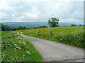
Farm road to Cefn
A private farm drive with views over the Wye Valley towards Hay Bluff and Twmpa.
Image: © Jonathan Billinger
Taken: 9 Jun 2010
0.18 miles
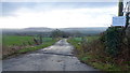
4
Road to Rhydspence
Looking south-west towards Wales.
Image: © Jonathan Billinger
Taken: 9 Jun 2010
0.19 miles
5
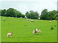
Sheep and lambs near Cefn
A very common sight in the Welsh/English borderlands.
Image: © Jonathan Billinger
Taken: 9 Jun 2010
0.22 miles
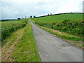
6
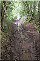
Muddy track near Brilley
This track has been adopted by a ditch which makes it very muddy, even in midsummer. A sign at the entrance to this track says Public Road!
Image: © Philip Halling
Taken: 25 Jun 2006
0.25 miles