IMAGES TAKEN NEAR TO
Whitney-on-Wye, HEREFORD, HR3 6HJ
Introduction
This page details the photographs taken nearby to HR3 6HJ by members of the Geograph project.
The Geograph project started in 2005 with the aim of publishing, organising and preserving representative images for every square kilometre of Great Britain, Ireland and the Isle of Man.

There are currently over 7.5m images from over14,400 individuals and you can help contribute to the project by visiting https://www.geograph.org.uk
Image Map
Images are licensed for reuse under creativecommons.org/licenses/by-sa/2.0
Notes
- Clicking on the map will re-center to the selected point.
- The higher the marker number, the further away the image location is from the centre of the postcode.
Image Listing (6 Images Found)
Images are licensed for reuse under creativecommons.org/licenses/by-sa/2.0
Image
Details
Distance
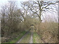
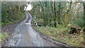
3
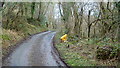
Pentre Grove Lane, 1
Looking west towards Rhos-goch and the Welsh border.
Image: © Jonathan Billinger
Taken: 10 Feb 2016
0.16 miles
4
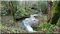
The Millhalf Brook
Looking downstream from the bridge in Image
Image: © Jonathan Billinger
Taken: 10 Feb 2016
0.19 miles
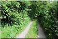
5
Pentre Grove Lane, 2
Looking east where the lane crosses the Millhalf Brook.
Image: © Jonathan Billinger
Taken: 10 Feb 2016
0.20 miles
6
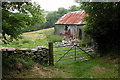
Old tin shed
Old tin shed along the lane from Pentre Grove.
Almost ten years later this same scene was photographed and remains unchanged, the sheet of old tin still rests against the shed and the stones in the wall are just the same, albeit with more moss. Image]
Image: © Philip Halling
Taken: 25 Jun 2006
0.20 miles