IMAGES TAKEN NEAR TO
Whitney-on-Wye, HEREFORD, HR3 6EL
Introduction
This page details the photographs taken nearby to HR3 6EL by members of the Geograph project.
The Geograph project started in 2005 with the aim of publishing, organising and preserving representative images for every square kilometre of Great Britain, Ireland and the Isle of Man.

There are currently over 7.5m images from over14,400 individuals and you can help contribute to the project by visiting https://www.geograph.org.uk
Image Map (Loading...)


Getting Data...Please wait
Leaflet Map data © OpenStreetMap
Images are licensed for reuse under creativecommons.org/licenses/by-sa/2.0
Notes
- Clicking on the map will re-center to the selected point.
- The higher the marker number, the further away the image location is from the centre of the postcode.
Image Listing (5 Images Found)
Images are licensed for reuse under creativecommons.org/licenses/by-sa/2.0
Image
Details
Distance
1
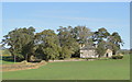
Stowe Farm, Whitney-on-Wye
Between 1813 and 1866 The Stowe was owned by John Monkhouse, a cousin of William Wordsworth's wife Mary Hutchinson. William never visited himself but his sister Dorothy came in 1814 and again in 1826. Monkhouse, who was blind, was a notable cattle and sheep breeder.
Image: © Philip Pankhurst
Taken: 26 Sep 2011
0.00 miles
2
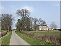
Stowe Farm
By the lane to Millhalf, overlooking the Wye flood plain.
Image: © Jonathan Billinger
Taken: 26 Mar 2007
0.02 miles
3
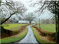
Stowe Lane
Looking south over the Wye floodplain.
This is the opposite view to Image taken 34 months earlier by the same photographer.
Image: © Jonathan Billinger
Taken: 29 Jan 2010
0.08 miles
4
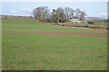
Farmland at Stowe
Farmland at Stowe viewed from the A438, the lane leads to Millhalf and Brilley. Stowe Farm can be seen on the right.
Image: © Philip Halling
Taken: 28 Jan 2012
0.10 miles
5
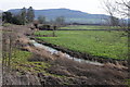
Farmland at Stowe in the Wye valley
Lower lying farmland at Stowe in the Wye valley, Merbach Hill can be seen in the background.
Image: © Philip Halling
Taken: 28 Jan 2012
0.22 miles