
IMAGES TAKEN NEAR TO
Whitney-on-Wye, HEREFORD, HR3 6EH
Introduction
This page details the photographs taken nearby to HR3 6EH by members of the Geograph project.
The Geograph project started in 2005 with the aim of publishing, organising and preserving representative images for every square kilometre of Great Britain, Ireland and the Isle of Man.

There are currently over 7.5m images from over14,400 individuals and you can help contribute to the project by visiting https://www.geograph.org.uk
Image Map
Images are licensed for reuse under creativecommons.org/licenses/by-sa/2.0
Notes
- Clicking on the map will re-center to the selected point.
- The higher the marker number, the further away the image location is from the centre of the postcode.
Image Listing (104 Images Found)
Images are licensed for reuse under creativecommons.org/licenses/by-sa/2.0
Image
Details
Distance
1
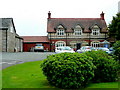
The Boat Inn, Whitney-on-Wye
Bypassed by the main A438 Brecon to Hereford road.
Image: © Jonathan Billinger
Taken: 10 Jun 2009
0.03 miles
2

Canoes Loading
At the Boat Inn, Whitney on Wye, Herefordshire, for the 10-mile haul back up to Glasbury.
Image: © mfjordan
Taken: 18 Apr 2007
0.08 miles
3
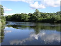
River Wye
River Wye from the garden of The Boat Inn
Image: © Richard Greenwood
Taken: 4 Jul 2004
0.08 miles
4
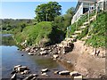
Canoe Landing
At the Boat Inn on the left bank of the Wye at Whitney.
(Said establishment providing a nice pint of John Smiths to put back what the paddling took out...)
Image: © mfjordan
Taken: 18 Apr 2007
0.10 miles
5

Church Barn (Whitney on Wye)
Church Barn has gone through a lot in the first quarter of the C21, most of which can be seen on the Google Maps street view from 2009-24. The weather-boarded and stone rubble structure is the oldest part of the building, and the brick extension to the structure can be seen here Image
This building housed a farm shop called 'Church Barn Farm Shop' from around 2011-17, then it housed a branch of Carrot & Wine Stores (Wormelow) from September 2017 until 2020, which I remember seeing from the adjacent A438 road back then. During that time, a food hall, café and gallery were in the building, and the doors bearing the logo of said store were still on the south side of the building on my visit. Church Barn was sold at auction in May 2024, but it seems to have gone up for sale again.
Image: © Fabian Musto
Taken: 24 Jul 2026
0.11 miles
6

Church Barn (Whitney on Wye)
Church Barn has gone through a lot in the first quarter of the C21, most of which can be seen on the Google Maps street view from 2009-24. The older part of this building must be the part weather-boarded and stone rubble structure to the left, and the brick addition to the right was probably added in the first half of the C20.
This building housed a farm shop called 'Church Barn Farm Shop' from around 2011-17, then it housed a branch of Carrot & Wine Stores (Wormelow) from September 2017 until 2020, which I remember seeing from the adjacent A438 road back then. During that time, a food hall, café and gallery were in the building, and the doors bearing the logo of said store were still on the south side of the building on my visit. Church Barn was sold at auction in May 2024, but it seems to have gone up for sale again.
Image: © Fabian Musto
Taken: 24 Jul 2026
0.11 miles
7
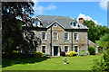
Wardour House, Whitney on Wye
Built in 1735 as the Rectory. Listed GII. 'Built to replace the former rectory destroyed in the floods of 1735' says the official Historic England listing. Replaced in 1848 by the Rev Henry Dew, who built himself a Tudor gothic pile a quarter of a mile to the North East.
Image: © Philip Pankhurst
Taken: 5 Jun 2024
0.12 miles
8
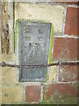
Ordnance Survey Flush Bracket (2694)
This OS Flush Bracket can be found on the east face of the house. It marks a point 69.146m above mean sea level.
Image: © Adrian Dust
Taken: 19 Nov 2015
0.13 miles
9

Wardour House (Whitney on Wye)
Fine Georgian era house by the A438 road in Whitney on Wye, built as the rectory around 1735 when the River Wye floods of 1720 affected both the predecessor here and Image When a newer rectory was built further up the hill in the mid-C19 Image, the building here became known as Church House as seen on OS maps from the late C19 to the mid-C20. Wardour House was grade II listed in 1988.
Image: © Fabian Musto
Taken: 24 Jul 2026
0.13 miles
10

Whitney on Wye Community Garden
This community garden is placed opposite the village hall, and the sign on the right was installed in 2022, which has motifs suggesting it was added during the Platinum Jubilee of Elizabeth II in early June 2022.
Image: © Fabian Musto
Taken: 24 Jul 2026
0.15 miles