IMAGES TAKEN NEAR TO
Letton, HEREFORD, HR3 6DN
Introduction
This page details the photographs taken nearby to HR3 6DN by members of the Geograph project.
The Geograph project started in 2005 with the aim of publishing, organising and preserving representative images for every square kilometre of Great Britain, Ireland and the Isle of Man.

There are currently over 7.5m images from over14,400 individuals and you can help contribute to the project by visiting https://www.geograph.org.uk
Image Map (Loading...)


Getting Data...Please wait
Leaflet Map data © OpenStreetMap
Images are licensed for reuse under creativecommons.org/licenses/by-sa/2.0
Notes
- Clicking on the map will re-center to the selected point.
- The higher the marker number, the further away the image location is from the centre of the postcode.
Image Listing (5 Images Found)
Images are licensed for reuse under creativecommons.org/licenses/by-sa/2.0
Image
Details
Distance
1
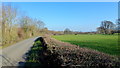
Low-lying land and lane at Letton
Looking north towards Ailey by the entrance to Waterloo.
Image: © Jonathan Billinger
Taken: 1 Feb 2012
0.11 miles
3
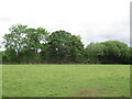
Pasture near Letton
A scattering of houses are partially obscured by woodland.
Image: © Jonathan Billinger
Taken: 1 Feb 2012
0.20 miles
4
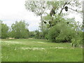
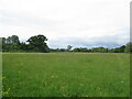
The Sturts East nature reserve
Hay meadow between Kinnersley and Letton
Image: © Richard Webb
Taken: 23 May 2022
0.23 miles