1
Gate to Letton Court
The gateposts are topped by 2 Great Western Railway signal finials - the left hand one has signs of red paint on the orb. Collectors should note that they are very well secured.
Image: © Philip Pankhurst
Taken: 14 Sep 2013
0.08 miles
2
Stable block, Letton Court
Dating from 1862
Image: © Philip Pankhurst
Taken: 8 Jul 2012
0.09 miles
3
St John the Baptist, Letton
The interior, looking West. Rarely open, it welcomed travellers with snacks and refreshments, including directions to the kettle in the vestry on the week-end of the Festival of Churches.
Image: © Philip Pankhurst
Taken: 14 Sep 2013
0.10 miles
4
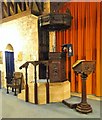
St John the Baptist, Letton
The fabulous 18th century pulpit and lectern, reputedly from All Saints in Bristol.
Image: © Philip Pankhurst
Taken: 14 Sep 2013
0.10 miles
5
St John the Baptist, Letton
The South door, dating from the early 12th century. The door and ironwork look equally ancient.
Image: © Philip Pankhurst
Taken: 14 Sep 2013
0.10 miles
6
St John the Baptist, Letton
Just off the main road with only Letton Court and an ancient cottage for company. Well worth risking your life at the concealed turning off the Brecon road.
Image: © Philip Pankhurst
Taken: 8 Jul 2012
0.10 miles
7
St John the Baptist, Letton
The chancel, seen from the pulpit steps.
Image: © Philip Pankhurst
Taken: 14 Sep 2013
0.10 miles
8
Ordnance Survey Cut Mark
This OS cut mark can be found on the east face of St John's Church. It marks a point 65.173m above mean sea level.
Image: © Adrian Dust
Taken: 19 Nov 2015
0.10 miles
9
Ordnance Survey Cut Mark
This OS cut mark can be found on the east face of St John's Church. It marks a point 65.173m above mean sea level.
Image: © Adrian Dust
Taken: 24 Mar 2017
0.10 miles
10
Twin towers, Letton
The tower of St John the Baptist dates from the 14th century; the gateway tower to the Letton Court stable block, dating from 1862, was designed by the highly individual High Victorian architect Samuel Sanders Teulon.
Image: © Philip Pankhurst
Taken: 8 Jul 2012
0.10 miles


