IMAGES TAKEN NEAR TO
Clyro, HEREFORD, HR3 5RY
Introduction
This page details the photographs taken nearby to HR3 5RY by members of the Geograph project.
The Geograph project started in 2005 with the aim of publishing, organising and preserving representative images for every square kilometre of Great Britain, Ireland and the Isle of Man.

There are currently over 7.5m images from over14,400 individuals and you can help contribute to the project by visiting https://www.geograph.org.uk
Image Map
Images are licensed for reuse under creativecommons.org/licenses/by-sa/2.0
Notes
- Clicking on the map will re-center to the selected point.
- The higher the marker number, the further away the image location is from the centre of the postcode.
Image Listing (6 Images Found)
Images are licensed for reuse under creativecommons.org/licenses/by-sa/2.0
Image
Details
Distance
1
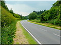
A438 near Cabalva Farm 2
Looking south-west towards Brecon.
Image: © Jonathan Billinger
Taken: 10 Jun 2009
0.07 miles
2
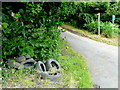
Tyre fly tip
By the A438 at the point where the Offa's Dyke Path heads north away from the Wye.
Image: © Jonathan Billinger
Taken: 10 Jun 2009
0.08 miles
3
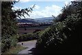
Road from Cwm
Descent to the A438 on the Offa's Dyke Path.
Image: © Richard Webb
Taken: 1 Aug 1989
0.08 miles
4
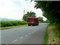
A438 near Bronydd
Looking south-west towards Brecon.
Image: © Jonathan Billinger
Taken: 10 Jun 2009
0.14 miles
5
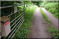
Entrance to Cwm Farm
Private road leading to Cwm Farm.
Image: © Philip Halling
Taken: 25 Jun 2006
0.22 miles
6
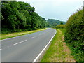
A438 near Cabalva Farm
Looking north-east towards Hereford.
Image: © Jonathan Billinger
Taken: 10 Jun 2009
0.25 miles