IMAGES TAKEN NEAR TO
Hay-on-Wye, HEREFORD, HR3 5PR
Introduction
This page details the photographs taken nearby to HR3 5PR by members of the Geograph project.
The Geograph project started in 2005 with the aim of publishing, organising and preserving representative images for every square kilometre of Great Britain, Ireland and the Isle of Man.

There are currently over 7.5m images from over14,400 individuals and you can help contribute to the project by visiting https://www.geograph.org.uk
Image Map
Images are licensed for reuse under creativecommons.org/licenses/by-sa/2.0
Notes
- Clicking on the map will re-center to the selected point.
- The higher the marker number, the further away the image location is from the centre of the postcode.
Image Listing (6 Images Found)
Images are licensed for reuse under creativecommons.org/licenses/by-sa/2.0
Image
Details
Distance
1
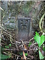
Ordnance Survey Flush Bracket (2700)
This OS Flush Bracket can be found on the NW parapet of the old bridge over Digedi Brook. It marks a point 88.496m above mean sea level.
Image: © Adrian Dust
Taken: 8 Jun 2014
0.08 miles
3
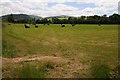
Field of silage bales
Field of silage bales near Old Ffordd-fawr.
Image: © Philip Halling
Taken: 21 Jun 2014
0.09 miles
4
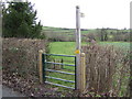
Footpath to the Digedi Brook
Near Llanigon.
Image: © Jonathan Billinger
Taken: 19 Jan 2007
0.18 miles
5
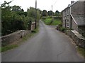
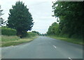
Llanigon: the bridge over Digedi Brook
Image: © Keith Salvesen
Taken: 23 Sep 2009
0.23 miles