IMAGES TAKEN NEAR TO
Glasbury, HEREFORD, HR3 5NZ
Introduction
This page details the photographs taken nearby to HR3 5NZ by members of the Geograph project.
The Geograph project started in 2005 with the aim of publishing, organising and preserving representative images for every square kilometre of Great Britain, Ireland and the Isle of Man.

There are currently over 7.5m images from over14,400 individuals and you can help contribute to the project by visiting https://www.geograph.org.uk
Image Map
Images are licensed for reuse under creativecommons.org/licenses/by-sa/2.0
Notes
- Clicking on the map will re-center to the selected point.
- The higher the marker number, the further away the image location is from the centre of the postcode.
Image Listing (3 Images Found)
Images are licensed for reuse under creativecommons.org/licenses/by-sa/2.0
Image
Details
Distance
2
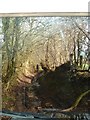
A bit narrow toward the end!
This is about 100yds from the end of the lane. The worst bramble part already over, but this part just tricky with trees protruding into the path of the upper vehicle. Earlier on a centre rut makes it... er... interesting.
Image: © John Ling
Taken: 15 Mar 2009
0.18 miles
3
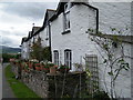
Cottage on Ciltwrch Common
A hamlet on the edge of hill country north of the Wye at Glasbury.
Image: © Jonathan Billinger
Taken: 19 Oct 2007
0.22 miles