
IMAGES TAKEN NEAR TO
Glasbury, HEREFORD, HR3 5NE
Introduction
This page details the photographs taken nearby to HR3 5NE by members of the Geograph project.
The Geograph project started in 2005 with the aim of publishing, organising and preserving representative images for every square kilometre of Great Britain, Ireland and the Isle of Man.

There are currently over 7.5m images from over14,400 individuals and you can help contribute to the project by visiting https://www.geograph.org.uk
Image Map
Images are licensed for reuse under creativecommons.org/licenses/by-sa/2.0
Notes
- Clicking on the map will re-center to the selected point.
- The higher the marker number, the further away the image location is from the centre of the postcode.
Image Listing (6 Images Found)
Images are licensed for reuse under creativecommons.org/licenses/by-sa/2.0
Image
Details
Distance
1
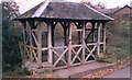
Well, Ffynnon Gynydd, Glasbury
This is by the roadside just north of the road junction by the common, on which there was probably a monastery of the Celtic church.
Image: © Humphrey Bolton
Taken: Unknown
0.03 miles
2

View to the ancient well
See Image for details of this feature in Ffynnon Gynydd.
Image: © Jonathan Billinger
Taken: 29 Jan 2015
0.03 miles
3

Ffynnon Gynydd
Entering the common land, there is also a relic pre-Worboys school sign to enjoy.
Image: © Jonathan Billinger
Taken: 29 Jan 2015
0.07 miles
4
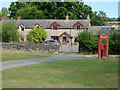
Communications hub, Ffynnon Gynydd
Post office, post box and [probably] defunct telephone kiosk in this small hillside village.
Image: © Gordon Hatton
Taken: 20 Sep 2022
0.09 miles
5

Cottages, phone and post box, Ffynnon Gynydd
An isolated village in the hills to the north-west of Glasbury.
Image: © Jonathan Billinger
Taken: 29 Jan 2015
0.10 miles
6

Ffynnon Gynydd Primary School
An isolated village school on the edge of Ffynnon Gynydd Common.
Image: © Jonathan Billinger
Taken: 29 Jan 2015
0.13 miles