IMAGES TAKEN NEAR TO
Glasbury, HEREFORD, HR3 5LQ
Introduction
This page details the photographs taken nearby to HR3 5LQ by members of the Geograph project.
The Geograph project started in 2005 with the aim of publishing, organising and preserving representative images for every square kilometre of Great Britain, Ireland and the Isle of Man.

There are currently over 7.5m images from over14,400 individuals and you can help contribute to the project by visiting https://www.geograph.org.uk
Image Map
Images are licensed for reuse under creativecommons.org/licenses/by-sa/2.0
Notes
- Clicking on the map will re-center to the selected point.
- The higher the marker number, the further away the image location is from the centre of the postcode.
Image Listing (5 Images Found)
Images are licensed for reuse under creativecommons.org/licenses/by-sa/2.0
Image
Details
Distance
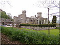
1
Maesllwch Castle and estate
Taken on the Wye Valley Walk.
Image: © David Purchase
Taken: 13 May 2012
0.02 miles
2

Maesllwch Castle Near Glasbury
An aerial view of Maesllwch Castle. This Castle is set in glorious parkland enjoying a commanding position overlooking the beautiful Wye Valley near Glasbury.
Image: © RAY JONES
Taken: 19 Oct 2009
0.03 miles
3
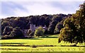
Maesllwch Castle
The remains of the castellated country house by Robert Lugar, for the de Wintons, who still own the estate. Much of it was demolished in 1951. Set in glorious mature parkland.
Image: © Philip Pankhurst
Taken: 20 Sep 2011
0.04 miles