IMAGES TAKEN NEAR TO
Glasbury, HEREFORD, HR3 5LP
Introduction
This page details the photographs taken nearby to HR3 5LP by members of the Geograph project.
The Geograph project started in 2005 with the aim of publishing, organising and preserving representative images for every square kilometre of Great Britain, Ireland and the Isle of Man.

There are currently over 7.5m images from over14,400 individuals and you can help contribute to the project by visiting https://www.geograph.org.uk
Image Map (Loading...)


Getting Data...Please wait
Leaflet Map data © OpenStreetMap
Images are licensed for reuse under creativecommons.org/licenses/by-sa/2.0
Notes
- Clicking on the map will re-center to the selected point.
- The higher the marker number, the further away the image location is from the centre of the postcode.
Image Listing (15 Images Found)
Images are licensed for reuse under creativecommons.org/licenses/by-sa/2.0
Image
Details
Distance
1
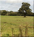
Field on the north side of Grange Farm near Glasbury
Viewed from the B4350 between Glasbury and Cwm-bach.
Image: © Jaggery
Taken: 11 Sep 2011
0.04 miles
2
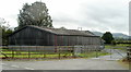
Farm building, Grange Farm near Glasbury
Viewed across the B4350 between Glasbury and Cwm-bach.
Image: © Jaggery
Taken: 11 Sep 2011
0.08 miles
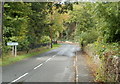
3
Road from Glasbury to Cwm-bach
Viewed from near the Brookside junction, looking NW along the B4350 in the direction of Cwm-bach.
Image: © Jaggery
Taken: 11 Sep 2011
0.14 miles
4
SE boundary of Cwm-bach, Powys
The B4350 from Glasbury reaches Cwm-bach.
Image: © Jaggery
Taken: 11 Sep 2011
0.14 miles
5
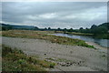
Looking north along the River Wye from Glasbury Bridge
Image: © Angela Jones
Taken: 6 Aug 2004
0.18 miles
6
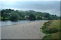
Looking south along the River Wye at Glasbury
Image: © Angela Jones
Taken: 6 Aug 2004
0.18 miles
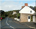
7
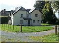
Harrow Lodge, Glasbury
Located on the north side of the Maesllwch Arms Hotel. http://www.geograph.org.uk/photo/2737726
Private residence formerly a lodge on the southern entrance drive into Maesllwch Castle. Image
Image: © Jaggery
Taken: 11 Sep 2011
0.19 miles
8
Wye Valley Walk, Glasbury
This part of the Wye Valley Walk is on the north bank of the River Wye west of Glasbury Bridge.
Image: © Jaggery
Taken: 11 Sep 2011
0.20 miles
9

Eastern side of Woodlands Outdoor Education Centre, Cwm-bach
Viewed from the B4350. Activities provided by the centre include canoeing and kayaking, gorge walking, caving, mountain walking, climbing & abseiling, and high ropes.
The site (in Powys, Wales) is owned by Oxfordshire County Council.
Image: © Jaggery
Taken: 11 Sep 2011
0.20 miles
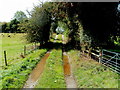
10
Approaching Glasbury
On the Wye Valley Walk.
Image: © David Purchase
Taken: 13 May 2012
0.21 miles