IMAGES TAKEN NEAR TO
Glasbury, HEREFORD, HR3 5LN
Introduction
This page details the photographs taken nearby to HR3 5LN by members of the Geograph project.
The Geograph project started in 2005 with the aim of publishing, organising and preserving representative images for every square kilometre of Great Britain, Ireland and the Isle of Man.

There are currently over 7.5m images from over14,400 individuals and you can help contribute to the project by visiting https://www.geograph.org.uk
Image Map
Images are licensed for reuse under creativecommons.org/licenses/by-sa/2.0
Notes
- Clicking on the map will re-center to the selected point.
- The higher the marker number, the further away the image location is from the centre of the postcode.
Image Listing (67 Images Found)
Images are licensed for reuse under creativecommons.org/licenses/by-sa/2.0
Image
Details
Distance
1
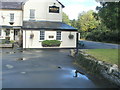
Old water pump outside the Maesllwch Arms Hotel, Glasbury
The pump is alongside the wall at centre right, and partly reflected in a puddle.
It is in front of Grade II listed Maesllwch Arms Hotel. http://www.geograph.org.uk/photo/2737726
Image: © Jaggery
Taken: 11 Sep 2011
0.03 miles
2
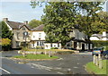
Grade II listed Maesllwch Arms Hotel, Glasbury
The hotel is set back from the north side of the B4350. Grade II listed in January 1996.
Image: © Jaggery
Taken: 11 Sep 2011
0.03 miles
3
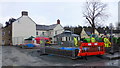
Remodelling the Maesllwch Arms
The work is on the exterior landscaping by Glasbury village street.
The 'Sllwch' is a popular local hostelry.
Image: © Jonathan Billinger
Taken: 29 Jan 2015
0.03 miles
4
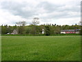
Approaching Glasbury
On the Wye Valley Walk.
Image: © David Purchase
Taken: 13 May 2012
0.04 miles
5
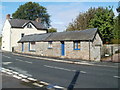
Former tea rooms, Glasbury
This 18 metre long single-storey building, opposite the War Memorial, http://www.geograph.org.uk/photo/2737680 was formerly a tea room where home-made arts and crafts were also on sale.
Image: © Jaggery
Taken: 11 Sep 2011
0.04 miles
6
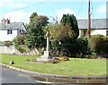
Glasbury War Memorial
The stone cross memorial records the names of the seven men from the parish who killed in the Great War (1914-1918), later known as the First World War, and the four who were killed in the Second World War.
Image: © Jaggery
Taken: 11 Sep 2011
0.04 miles
7
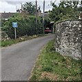
Dead-end road in Glasbury, Powys
Faded in August 2024, a No Through Road sign is on the left.
Image: © Jaggery
Taken: 4 Aug 2024
0.04 miles
8
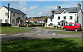
NW corner of The Green, Glasbury
The village green is on the north bank of the River Wye.
Image: © Jaggery
Taken: 11 Sep 2011
0.05 miles
9
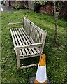
Bill Windham Memorial Bench on The Green, Glasbury, Powys
The small plaque on the bench shows
"In memory of
Bill Windham
(1926 - 2021)
who lived at Parc Gwynne from 1987"
Image: © Jaggery
Taken: 4 Aug 2024
0.05 miles
10
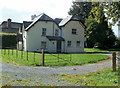
Harrow Lodge, Glasbury
Located on the north side of the Maesllwch Arms Hotel. http://www.geograph.org.uk/photo/2737726
Private residence formerly a lodge on the southern entrance drive into Maesllwch Castle. Image
Image: © Jaggery
Taken: 11 Sep 2011
0.05 miles