IMAGES TAKEN NEAR TO
Clyro, HEREFORD, HR3 5JT
Introduction
This page details the photographs taken nearby to HR3 5JT by members of the Geograph project.
The Geograph project started in 2005 with the aim of publishing, organising and preserving representative images for every square kilometre of Great Britain, Ireland and the Isle of Man.

There are currently over 7.5m images from over14,400 individuals and you can help contribute to the project by visiting https://www.geograph.org.uk
Image Map
Images are licensed for reuse under creativecommons.org/licenses/by-sa/2.0
Notes
- Clicking on the map will re-center to the selected point.
- The higher the marker number, the further away the image location is from the centre of the postcode.
Image Listing (10 Images Found)
Images are licensed for reuse under creativecommons.org/licenses/by-sa/2.0
Image
Details
Distance
1

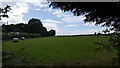
Haymaking near Llowes Common
A small field cut for hay near Llowes Common.
Image: © Philip Halling
Taken: 21 Jun 2014
0.06 miles
2
Grass harvested
Bales awaiting collection.
Image: © Peter Mackenzie
Taken: 3 Aug 2019
0.06 miles
6
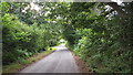
Rural road
The road through Llowes Common.
Image: © Peter Mackenzie
Taken: 3 Aug 2019
0.18 miles
7
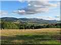
Hillside at Old Forest
A view across fields adjacent to Old Forest House towards the distant line of the Black Mountains.
Image: © Gordon Hatton
Taken: 16 Sep 2022
0.20 miles
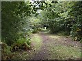
8
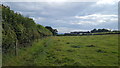
Path by the hedge
The public footpath runs beside the hedge.
Image: © Peter Mackenzie
Taken: 3 Aug 2019
0.21 miles
9
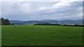
Field and mountain
A view over the Wye valley towards the Black mountains.
Image: © Peter Mackenzie
Taken: 3 Aug 2019
0.22 miles
10
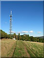
Communications mast at Old Forest
The mast stands by a private track between Old Forest farm and Old Forest House.
Image: © Gordon Hatton
Taken: 16 Sep 2022
0.22 miles